
Datoteka:Aeolian Islands.jpg

Veličina ovog prikaza: 396 × 599 piksela. Ostale razlučivosti: 159 × 240 piksela | 317 × 480 piksela | 508 × 768 piksela | 677 × 1.024 piksela | 2.032 × 3.072 piksela.
Vidi sliku u punoj veličini (2.032 × 3.072 piksela, veličina datoteke: 610 KB, MIME tip: image/jpeg)
| Ova je datoteka sa Zajedničkog poslužitelja i mogu je rabiti drugi projekti. Opis s njezine stranice s opisom datoteke prikazan je ispod. |
Sažetak
| Opis |
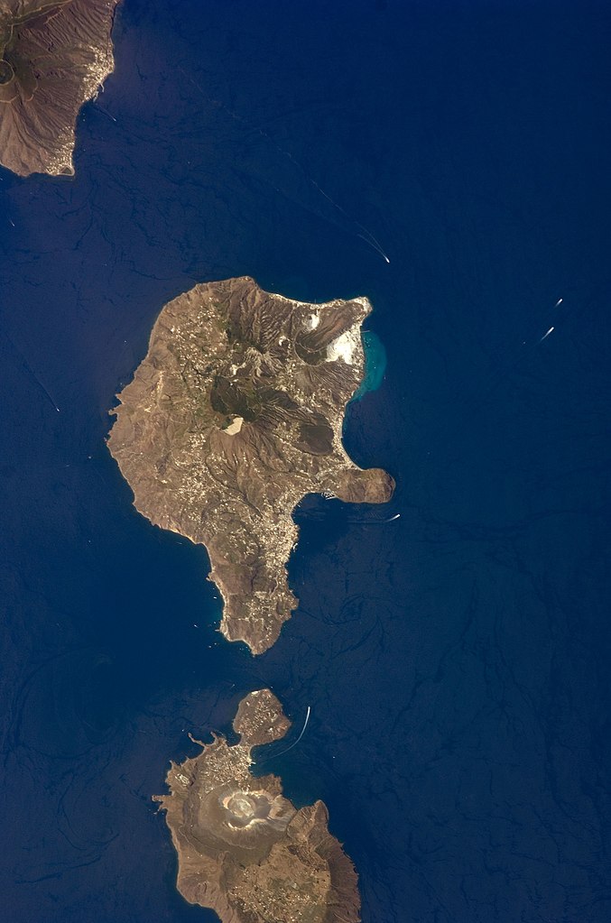
English: This detailed astronaut photograph features Lipari Island and the northern portion of Vulcano Island. Tan, speckled areas on both islands are urban areas and towns. Lipari is the largest of the Aeolian Islands, and it is a popular tourist destination due to its rugged volcanic topography and beaches (several boat wakes are visible around the islands). White pumice beaches and caves are located along the northern and northeastern coastlines of Lipari; black sand beaches derived from lava flows can also be found on the island. The most recent eruptive activity on Lipari took place from approximately AD 580–729.
|
||||||||||||||||||||||||||||||||||||||||||||||||||
| Datum | |||||||||||||||||||||||||||||||||||||||||||||||||||
| Izvor | NASA Earth Observatory | ||||||||||||||||||||||||||||||||||||||||||||||||||
| Autor | This image was taken by the NASA Expedition 17 crew. | ||||||||||||||||||||||||||||||||||||||||||||||||||
| Lokacija kamere | | Ova i druge slike na njihovim lokacijama na: OpenStreetMap |
|---|
This image or video was catalogued by Johnson Space Center of the United States National Aeronautics and Space Administration (NASA) under Photo ID: ISS017-E-9777. This tag does not indicate the copyright status of the attached work. A normal copyright tag is still required. See Commons:Licensing. Other languages:
|
This photograph was acquired with a Nikon D2Xs digital camera fitted with a 400 mm lens, and is provided by the ISS Crew Earth Observations experiment and the Image Science & Analysis Laboratory, Johnson Space Center.
Licencija
| This file is in the public domain in the United States because it was solely created by NASA. NASA copyright policy states that "NASA material is not protected by copyright unless noted". (See Template:PD-USGov, NASA copyright policy page or JPL Image Use Policy.) | ||
 |
Warnings:
|
Povijest datoteke
Kliknite na datum/vrijeme kako biste vidjeli datoteku kakva je tada bila.
| Datum/Vrijeme | Minijatura | Dimenzije | Suradnik | Komentar | |
|---|---|---|---|---|---|
| sadašnja | 03:45, 15. studenoga 2013. | | 2.032 × 3.072 (610 KB) | Rotatebot | Bot: Image rotated by 90° |
| 19:07, 4. svibnja 2011. |  | 3.072 × 2.039 (555 KB) | Originalwana | higher res | |
| 18:23, 23. svibnja 2009. |  | 939 × 586 (115 KB) | Originalwana | {{Information |Description={{en|1=This detailed astronaut photograph features Lipari Island and the northern portion of Vulcano Island. Tan, speckled areas on both islands are urban areas and towns. Lipari is the largest of the Aeolian Islands, and it is |
Uporaba datoteke
Na ovu sliku vode poveznice sa sljedećih stranica:
Globalna uporaba datoteke
Sljedeći wikiji rabe ovu datoteku:
- Uporaba na ar.wikipedia.org
- Uporaba na ast.wikipedia.org
- Uporaba na ca.wikipedia.org
- Uporaba na ceb.wikipedia.org
- Uporaba na cy.wikipedia.org
- Uporaba na de.wikivoyage.org
- Uporaba na el.wikipedia.org
- Uporaba na en.wikipedia.org
- Uporaba na en.wikivoyage.org
- Uporaba na es.wikipedia.org
- Uporaba na eu.wikipedia.org
- Uporaba na fr.wikivoyage.org
- Uporaba na gl.wikipedia.org
- Uporaba na he.wikivoyage.org
- Uporaba na id.wikipedia.org
- Uporaba na it.wikipedia.org
- Uporaba na it.wikivoyage.org
- Uporaba na ko.wikipedia.org
- Uporaba na lb.wikipedia.org
- Uporaba na nl.wikipedia.org
- Uporaba na ro.wikipedia.org
- Uporaba na sl.wikipedia.org
- Uporaba na www.wikidata.org
- Uporaba na zh-yue.wikipedia.org
- Uporaba na zh.wikipedia.org