
Datoteka:Balkan boundaries1876map1914.png

Vidi sliku u punoj veličini (984 × 712 piksela, veličina datoteke: 73 KB, MIME tip: image/png)
| Ova je datoteka sa Zajedničkog poslužitelja i mogu je rabiti drugi projekti. Opis s njezine stranice s opisom datoteke prikazan je ispod. |

|
This map has been uploaded by Electionworld from en.wikipedia.org to enable the |
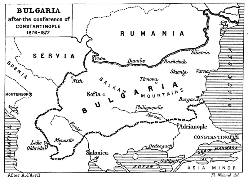
| Opis | Map from "Report of the International Commission To Inquire into the Causes and Conduct of the Balkan Wars" 1914. |
| Datum | Map printed and published 1914 |
| Izvor | a map |
| Autor | Source: [1] - JPG to PNG by Iain 09:30, 13 June 2006 (UTC) |
| Dopuštenje (Naknadna uporaba ove datoteke) |
Original File PD |
| Ostale inačice | Original Image Image:Balkan boundaries1876map1914.jpg now redundant |
|
Ovo je djelo u javnom vlasništvu u zemlji podrijetla i u drugim zemljama s rokom trajanja autorskih prava za života autora plus 70 godina ili manje.
| |
| Ova datoteka je identificirana kao slobodna od poznatih ograničenja po zakonu o autorskim pravima, uključujući sva povezana i srodna prava. | |
Povijest datoteke
Kliknite na datum/vrijeme kako biste vidjeli datoteku kakva je tada bila.
| Datum/Vrijeme | Minijatura | Dimenzije | Suradnik | Komentar | |
|---|---|---|---|---|---|
| sadašnja | 00:17, 21. prosinca 2006. | | 984 × 712 (73 KB) | Electionworld | {{ew|en|Iain}} {{Information| |Description = Map from "Report of the International Commission To Inquire into the Causes and Conduct of the Balkan Wars" 1914. |Date = Map printed and published 1914 |Author = Source: [http://www.lib.utexas.edu/maps/histori |
Uporaba datoteke
Na ovu sliku vode poveznice sa sljedećih stranica:
Globalna uporaba datoteke
Sljedeći wikiji rabe ovu datoteku:
- Uporaba na ar.wikipedia.org
- Uporaba na bg.wikipedia.org
- Uporaba na bs.wikipedia.org
- Uporaba na ca.wikipedia.org
- Uporaba na de.wikipedia.org
- Uporaba na el.wikipedia.org
- Uporaba na en.wikipedia.org
- Uporaba na et.wikipedia.org
- Uporaba na fa.wikipedia.org
- Uporaba na fr.wikipedia.org
- Uporaba na hu.wikipedia.org
- Uporaba na it.wikipedia.org
- Uporaba na mk.wikipedia.org
- Uporaba na nl.wikipedia.org
- Uporaba na no.wikipedia.org
- Uporaba na pl.wikipedia.org
- Uporaba na pt.wikipedia.org
- Uporaba na ro.wikipedia.org
- Uporaba na simple.wikipedia.org
- Uporaba na sk.wikipedia.org
- Uporaba na sq.wikipedia.org
- Uporaba na sr.wikipedia.org
- Uporaba na tr.wikipedia.org
- Uporaba na uk.wikipedia.org
- Uporaba na www.wikidata.org