
Datoteka:Ethnographic Iberia 200 BCE.PNG
Veličina ovog prikaza: 644 × 599 piksela. Ostale razlučivosti: 258 × 240 piksela | 516 × 480 piksela | 677 × 630 piksela.
Vidi sliku u punoj veličini (677 × 630 piksela, veličina datoteke: 59 KB, MIME tip: image/png)
| Ova je datoteka sa Zajedničkog poslužitelja i mogu je rabiti drugi projekti. Opis s njezine stranice s opisom datoteke prikazan je ispod. |
zayan
Sažetak

|
Dostupna je vektorska inačica (SVG) ove slike. Trebala bi se koristiti umjesto ove rasterske slike ako je kvalitetnija.
File:Ethnographic Iberia 200 BCE.PNG → File:Iberia 300BC-en.svg
Za više informacija o vektorskoj grafici, pročitajte o prelasku Zajedničkog poslužitelja na SVG. Također pročitajte informacije o podršci MediaWiki softvera slikama u SVG formatu. |
 |
| Opis |
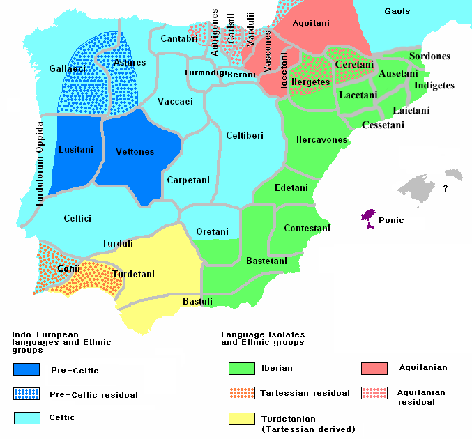
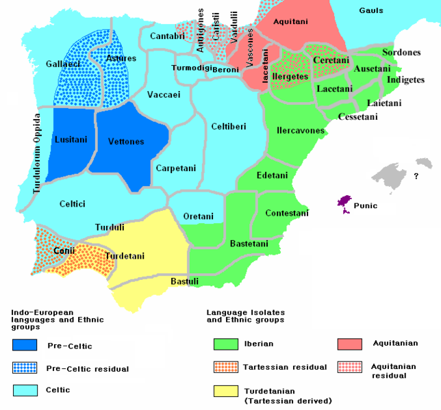
English: Ethnographic and Linguistic Map of the Iberian Peninsula at about 200 BCE (at the end of the Second Punic War). Based on the map done by Portuguese Archeologist Luís Fraga (luisfraga@arqueotavira.com), from the "Campo Arqueológico de Tavira" (Tavira Archeological Camp - official site), in Tavira, Algarve - Portugal. The reference map can be found at this location, and a pdf version, with extensive and detailed information on the criteria used, as well as the long bibliography used to source the map can be found here. |
| Datum | |
| Izvor | self-made from Image:Blank-peninsula Iberica.png |
| Autor | The Ogre |
| Ostale inačice | Italian version |
Licencija
Ja, nositelj autorskog prava za ovo djelo, ovime ga objavljujem pod sljedećim licencijama:

|
Dozvoljava se umnožavanje, dijeljenje i/ili mijenjanje ovog dokumenta pod uvjetima GNU-ove licence za slobodnu dokumentaciju, inačica 1.2 ili kasnija ako ju je objavio Free Software Foundation; bez nepromjenjivih ili obveznih dijelova i bez teksta na naslovnoj i/ili posljednjoj stranici. Kopija licencije je uključena u odjeljak naslovljen GNU-ove licence za slobodnu dokumentaciju. |
This file is licensed under the Creative Commons Attribution-Share Alike 4.0 International, 3.0 Unported, 2.5 Generic, 2.0 Generic and 1.0 Generic license.
- Slobodno smijete:
- dijeliti – umnožavati, distribuirati i javnosti priopćavati djelo
- remiksirati – prerađivati djelo
- Pod sljedećim uvjetima:
- imenovanje autora – Morate pripisati odgovarajuće autorske zasluge, dati poveznicu na licenciju, te naznačiti jesu li načinjene promjene autorskog djela. Prethodno navedeno možete učiniti na svaki razuman način, ali ne na način koji bi sugerirao da Vi ili Vaše korištenje licencorova djela ima izravno licencorovo odobrenje.
- dijeli pod istim uvjetima – Ako ovo djelo izmijenite, preoblikujete ili stvarate na osnovu tog materijala, svoje doprinose morate distribuirati pod istom ili kompatibilnom licencijom kao što je i licencija originala.
Možete odabrati licenciju prema vašem izboru.
Povijest datoteke
Kliknite na datum/vrijeme kako biste vidjeli datoteku kakva je tada bila.
| Datum/Vrijeme | Minijatura | Dimenzije | Suradnik | Komentar | |
|---|---|---|---|---|---|
| sadašnja | 12:25, 14. svibnja 2011. | | 677 × 630 (59 KB) | Jafeluv | Reverted to version as of 09:21, 25 April 2011 |
| 23:49, 13. svibnja 2011. |  | 677 × 630 (53 KB) | Ilario111 | Reverted to version as of 18:41, 22 April 2011 | |
| 11:21, 25. travnja 2011. |  | 677 × 630 (59 KB) | The Ogre | RV THE SAME OLD VANDAL Reverted to version as of 20:21, 13 April 2011 | |
| 20:41, 22. travnja 2011. |  | 677 × 630 (53 KB) | Madrid747 | Reverted to version as of 19:58, 13 April 2011 | |
| 22:21, 13. travnja 2011. |  | 677 × 630 (59 KB) | Jafeluv | Reverted to version as of 12:01, 9 April 2011 | |
| 21:58, 13. travnja 2011. |  | 677 × 630 (53 KB) | Windsurf101 | colors | |
| 14:01, 9. travnja 2011. |  | 677 × 630 (59 KB) | The Ogre | RV VANDAL - Reverted to version as of 18:34, 16 September 2008 | |
| 23:35, 8. travnja 2011. |  | 677 × 630 (53 KB) | Dumdum~commonswiki | More accurate | |
| 20:34, 16. rujna 2008. |  | 677 × 630 (59 KB) | Tautintanes | The Indigetes, Laietani, Cessetani and Ausetani minted their own coins with his name. They can’t be forgotten in a map like this. | |
| 09:11, 9. ožujka 2008. |  | 677 × 630 (44 KB) | The Ogre | Still another correction for the Baleares |
Uporaba datoteke
Na ovu sliku vode poveznice sa sljedećih stranica:
Globalna uporaba datoteke
Sljedeći wikiji rabe ovu datoteku:
- Uporaba na af.wikipedia.org
- Uporaba na ar.wikipedia.org
- Uporaba na arz.wikipedia.org
- Uporaba na ast.wikipedia.org
- Uporaba na ba.wikipedia.org
- Uporaba na bg.wikipedia.org
- Uporaba na br.wikipedia.org
- Uporaba na ca.wikipedia.org
- Uporaba na cy.wikipedia.org
- Uporaba na de.wikipedia.org
- Uporaba na el.wikipedia.org
- Uporaba na en.wikipedia.org
- Uporaba na en.wiktionary.org
- Uporaba na eo.wikipedia.org
- Uporaba na es.wikipedia.org
Pogledajte globalnu uporabu ove datoteke.