
Datoteka:Gale big.jpg
Veličina ovog prikaza: 800 × 554 piksela. Ostale razlučivosti: 320 × 222 piksela | 640 × 443 piksela | 1.024 × 709 piksela | 1.280 × 887 piksela | 2.953 × 2.046 piksela.
Vidi sliku u punoj veličini (2.953 × 2.046 piksela, veličina datoteke: 1,26 MB, MIME tip: image/jpeg)
| Ova je datoteka sa Zajedničkog poslužitelja i mogu je rabiti drugi projekti. Opis s njezine stranice s opisom datoteke prikazan je ispod. |


Sažetak
| Opis |
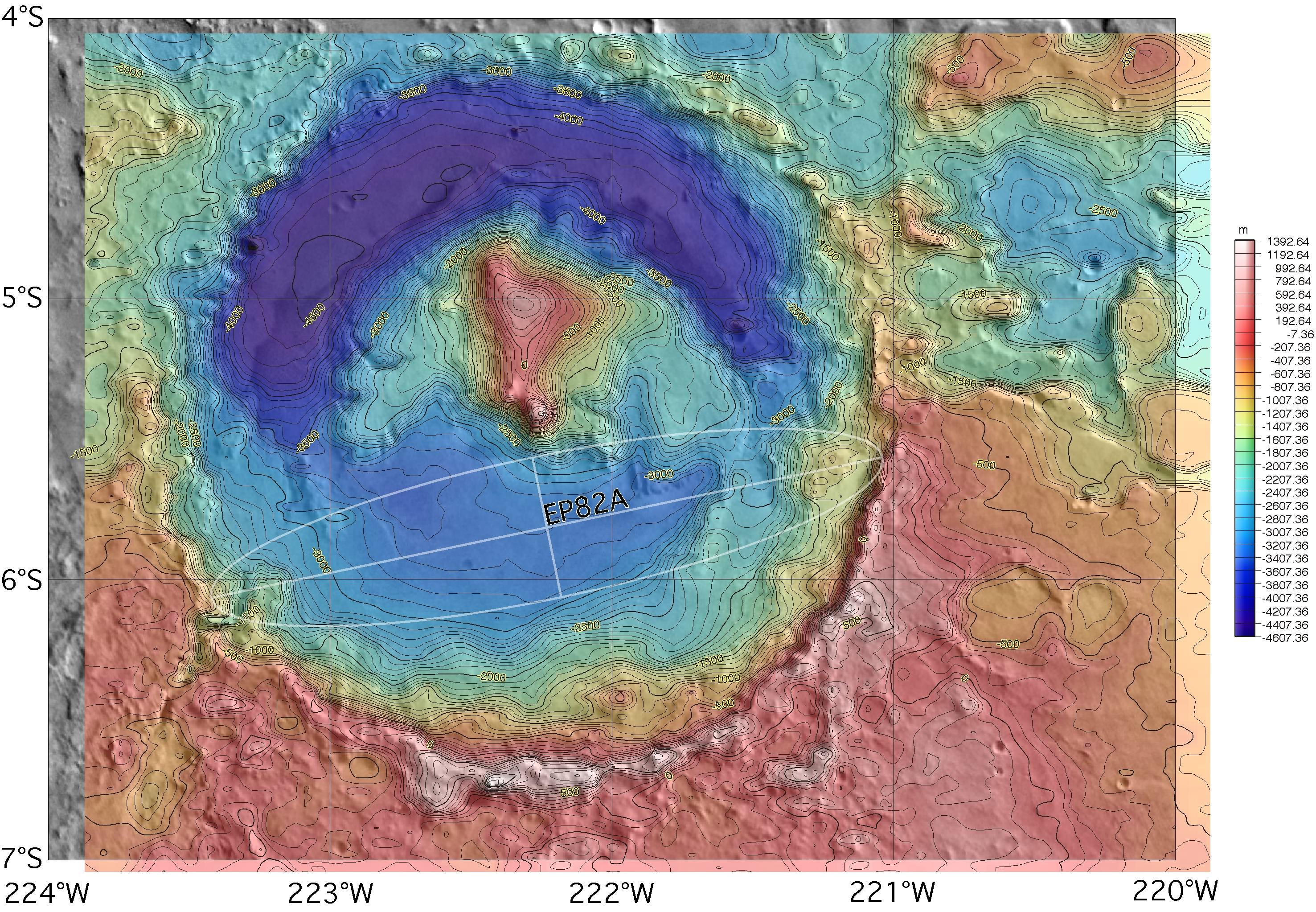
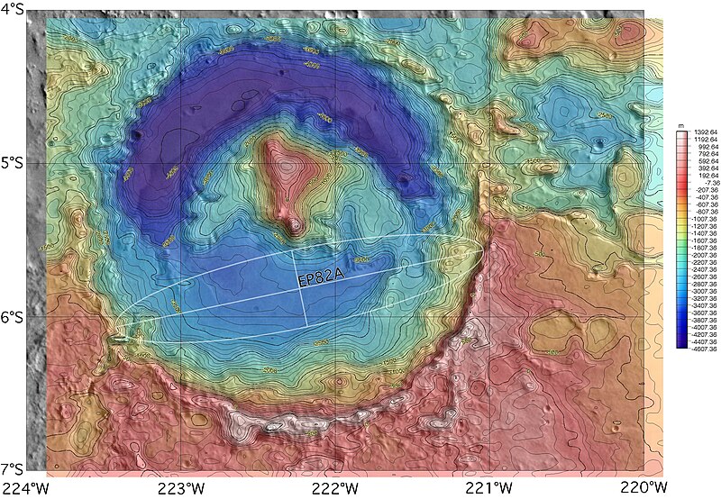
English: Topographic map of Gale crater on Mars, with the proposed but rejected landing ellipse for the MER-A superimposed. The MER lander was ultimately sent elsewhere, but the opposite side of the crater was selected for the 2011 Mars Science Laboratory rover. |
| Izvor | http://marsoweb.nas.nasa.gov/landingsites/mer2003/topsites/Gale/ (image link) |
| Autor | NASA; MOLA topographic map gridded, colored and contoured by Scott Anderson |
| Ostale inačice |
 |
| Lokacija na Marsu | Ova i druge slike na njihovim lokacijama na: Google zemljovidi |
|---|
Licencija
| This file is in the public domain in the United States because it was solely created by NASA. NASA copyright policy states that "NASA material is not protected by copyright unless noted". (See Template:PD-USGov, NASA copyright policy page or JPL Image Use Policy.) | ||
 |
Warnings:
|
Povijest datoteke
Kliknite na datum/vrijeme kako biste vidjeli datoteku kakva je tada bila.
| Datum/Vrijeme | Minijatura | Dimenzije | Suradnik | Komentar | |
|---|---|---|---|---|---|
| sadašnja | 04:08, 13. studenoga 2007. | | 2.953 × 2.046 (1,26 MB) | Bryan Derksen | {{Information |Description={{en|Topographic map of Gale crater on Mars, with the proposed landing ellipse for the en:Mars Exploration Rover MER-A superimposed. The MER lander was ultimately sent elsewhere, but the site is also a candidate for the upco |
Uporaba datoteke
Na ovu sliku vode poveznice sa sljedećih stranica:
Globalna uporaba datoteke
Sljedeći wikiji rabe ovu datoteku:
- Uporaba na be.wikipedia.org
- Uporaba na hy.wikipedia.org
- Uporaba na id.wikipedia.org
- Uporaba na pt.wikipedia.org
- Uporaba na ro.wikipedia.org
- Uporaba na uk.wikipedia.org