Datoteka:Map of Sealand with territorial waters.png

Stranica ne postoji na drugim jezicima.
Izvor: Wikipedija

Vidi sliku u punoj veličini(1.174 × 1.200 piksela, veličina datoteke: 55 KB, MIME tip: image/png)


Logo Wikimedijinog spremnika Ova je datoteka sa Zajedničkog poslužitelja i mogu je rabiti drugi projekti. Opis s njezine stranice s opisom datoteke prikazan je ispod.
Descripcion

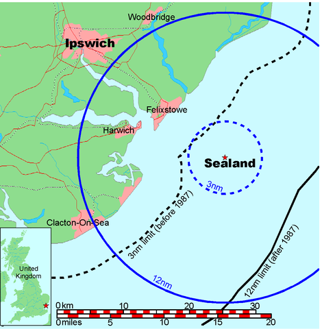
Map of Sealand

This is a map of the coast of England near Ipswich, showing the location of Sealand. The boundaries of the territorial water of the United Kingdom are also drawn, both the 3 nautical mile limit (5.556km) before 1987 and the 12nm limit (22.22km) after 1987. The same radii are also given around Sealand.

Note that these boundaries are derived based on the circular distance from the coastline, and not copied from official maps. This map is not suitable for navigation or for determining the boundaries of the UK territorial waters for legal or other purposes.

Stvaratelj
Map generated by DEMIS World Map Server and edited by Chris 73
Dopuštenje
(Naknadna uporaba ove datoteke)


Licensing:

This image was created by Chris 73. The image is licensed under a dual license; please choose either of the two licenses below as desired. Attribution to Wikipedia or another project of the Wikimedia foundation is required for both licenses if the image is used outside of projects of the Wikimedia foundation. Attribution to me is not required.

GNU head Dozvoljava se umnožavanje, dijeljenje i/ili mijenjanje ovog dokumenta pod uvjetima GNU-ove licence za slobodnu dokumentaciju, inačica 1.3 ili kasnija ako ju je objavio Free Software Foundation; bez nepromjenjivih ili obveznih dijelova i bez teksta na naslovnoj i/ili posljednjoj stranici. Kopija licencije je uključena u odjeljak naslovljen GNU-ove licence za slobodnu dokumentaciju.

w:hr:Creative Commons
imenovanje autora dijeli pod istim uvjetima
Slobodno smijete:
  • dijeliti – umnožavati, distribuirati i javnosti priopćavati djelo
  • remiksirati – prerađivati djelo
Pod sljedećim uvjetima:
  • imenovanje autora – Morate pripisati odgovarajuće autorske zasluge, dati poveznicu na licenciju, te naznačiti jesu li načinjene promjene autorskog djela. Prethodno navedeno možete učiniti na svaki razuman način, ali ne na način koji bi sugerirao da Vi ili Vaše korištenje licencorova djela ima izravno licencorovo odobrenje.
  • dijeli pod istim uvjetima – Ako ovo djelo izmijenite, preoblikujete ili stvarate na osnovu tog materijala, svoje doprinose morate distribuirati pod istom ili kompatibilnom licencijom kao što je i licencija originala.

"I want to use the image. How do I do that?"

You can use this image freely for any purpose, including commercial use, provided that you license it under one of the above licenses. My suggestion is to use the following text:

This Wikipedia and Wikimedia Commons image is from the user Chris 73 and is freely available at //commons.wikimedia.org/wiki/File:Map_of_Sealand_with_territorial_waters.png under the creative commons cc-by-sa 3.0 license.

For privacy reasons please use only "Chris 73" as author. If necessary, please translate the text in your language. For electronic use please include the links in the text as shown, for printed use please print the text as shown. If you use the image I would appreciate it if you would let me know on my talk page, but this is not required as long as you follow one of the above licenses.


 Geotemporal data
Bounding box
N: 52.1374339°N
W: 0.9973602°E E: 1.6619722°E
S: 51.6274989°N
Georeferencing View the georeferenced map in the Wikimaps Warper

Opisi

Dodajte kratko objašnjenje što predstavlja ova datoteka

Predmeti prikazani u ovoj datoteci

motiv

image/png

checksum engleski

845a9e08cbe7ed93bae6eeabe454399a76e3324f

data size engleski

56.131 Bajt

1.200 točka

1.174 točka

Povijest datoteke

Kliknite na datum/vrijeme kako biste vidjeli datoteku kakva je tada bila.

Datum/VrijemeMinijaturaDimenzijeSuradnikKomentar
sadašnja21:41, 9. srpnja 2006.Minijatura za inačicu od 21:41, 9. srpnja 2006.1.174 × 1.200 (55 KB)Chris 73update
12:00, 26. siječnja 2005.Minijatura za inačicu od 12:00, 26. siječnja 2005.1.024 × 1.046 (50 KB)Chris 73

Na ovu sliku vode poveznice sa sljedećih stranica:

Globalna uporaba datoteke

Sljedeći wikiji rabe ovu datoteku: