
Datoteka:NEO lake jau big.jpg

Veličina ovog prikaza: 600 × 600 piksela. Ostale razlučivosti: 240 × 240 piksela | 480 × 480 piksela | 750 × 750 piksela.
Vidi sliku u punoj veličini (750 × 750 piksela, veličina datoteke: 134 KB, MIME tip: image/jpeg)
| Ova je datoteka sa Zajedničkog poslužitelja i mogu je rabiti drugi projekti. Opis s njezine stranice s opisom datoteke prikazan je ispod. |
Sažetak
| Opis |
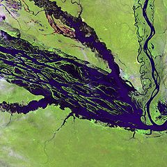
English: The Negro River flowing through the eastern edge of Brazil’s Jau National Park. The river is the big strip of blue running from left to right across the image, and the other blue ribbons are tributaries. Originating at the border of Venezuela and Brazil, the Negro River meets up with the Amazon in central Brazil to become its largest tributary. Half-submerged islands can be seen in the center of the river. Between November and April when the river is at its peak, many of these islands disappear. |
| Datum | |
| Izvor |
http://earthobservatory.nasa.gov/Newsroom/NewImages/images.php3?img_id=10843
|
| Autor | NASA and USGS EROS Data Center Satellite Systems Branch |
Licencija
This image is in the public domain in the United States because it only contains materials that originally came from the United States Geological Survey, an agency of the United States Department of the Interior. For more information, see the official USGS copyright policy.
|
Izvorna evidencija postavljanja
Izvorna stranica s opisom bila je ovdje. Niže navedena suradnička imena odnose se na en.wikipedia.
- 2003-11-23 05:55 Snoyes 750×750×8 (136760 bytes)
Povijest datoteke
Kliknite na datum/vrijeme kako biste vidjeli datoteku kakva je tada bila.
| Datum/Vrijeme | Minijatura | Dimenzije | Suradnik | Komentar | |
|---|---|---|---|---|---|
| sadašnja | 22:27, 4. travnja 2008. | | 750 × 750 (134 KB) | File Upload Bot (Magnus Manske) | {{BotMoveToCommons|en.wikipedia}} {{Information |Description={{en|'''Credit(s):''' [http://edc.usgs.gov/ USGS EROS Data Center] Satellite Systems Branch. '''Source:''' http://earthobservatory.nasa.gov/Newsroom/NewImages/images.php3?img_id=10843 ''?The |
Uporaba datoteke
Na ovu sliku vode poveznice sa sljedećih stranica:
Globalna uporaba datoteke
Sljedeći wikiji rabe ovu datoteku:
- Uporaba na ar.wikipedia.org
- Uporaba na ast.wikipedia.org
- Uporaba na ba.wikipedia.org
- Uporaba na be.wikipedia.org
- Uporaba na bg.wikipedia.org
- Uporaba na ca.wikipedia.org
- Uporaba na de.wikipedia.org
- Uporaba na de.wikivoyage.org
- Uporaba na en.wikipedia.org
- Uporaba na es.wikipedia.org
- Uporaba na eu.wikipedia.org
- Uporaba na fr.wikipedia.org
- Uporaba na he.wikipedia.org
- Uporaba na he.wikivoyage.org
- Uporaba na hi.wikipedia.org
- Uporaba na id.wikipedia.org
- Uporaba na it.wikivoyage.org
- Uporaba na ja.wikipedia.org
- Uporaba na ka.wikipedia.org
- Uporaba na ko.wikipedia.org
- Uporaba na lt.wikipedia.org
- Uporaba na mai.wikipedia.org
- Uporaba na ml.wikipedia.org
- Uporaba na mt.wikipedia.org
- Uporaba na ne.wikipedia.org
- Uporaba na nl.wikipedia.org
- Uporaba na pl.wikipedia.org
Pogledajte globalnu uporabu ove datoteke.