
Datoteka:United Kingdom labelled map7.png

Veličina ovog prikaza: 358 × 599 piksela. Ostale razlučivosti: 143 × 240 piksela | 287 × 480 piksela | 643 × 1.075 piksela.
Vidi sliku u punoj veličini (643 × 1.075 piksela, veličina datoteke: 86 KB, MIME tip: image/png)
| Ova je datoteka sa Zajedničkog poslužitelja i mogu je rabiti drugi projekti. Opis s njezine stranice s opisom datoteke prikazan je ispod. |

|
Dostupna je vektorska inačica (SVG) ove slike. Trebala bi se koristiti umjesto ove rasterske slike ako je kvalitetnija.
File:United Kingdom labelled map7.png → File:United Kingdom labelled map7 vector.svg
Za više informacija o vektorskoj grafici, pročitajte o prelasku Zajedničkog poslužitelja na SVG. Također pročitajte informacije o podršci MediaWiki softvera slikama u SVG formatu. |
 |
Sažetak
| Opis |
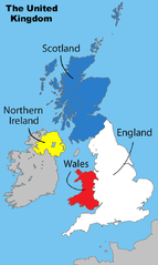
English: Divisions of the United Kingdom |
||
| Datum | 17. srpnja 2008. (izvorni datum postavljanja) | ||
| Izvor |
Vlastito djelo postavljača by Matt Lewis derived from: File:Uk map home nations.png |
||
| Autor | Amended Wikipedia image - amended by Matt Lewis for Wikipedia. | ||
| Dopuštenje (Naknadna uporaba ove datoteke) |
Matt Lewis, nositelj autorskog prava za ovo djelo, ovime ga objavljuje pod sljedećim licencijama: Ova datoteka je licencirana pod Creative Commons Imenovanje-Dijeli pod istim uvjetima 3.0 nelokaliziranom licencijom. Autor: Matt Lewis
Možete odabrati licenciju prema vašem izboru. |
||
| Ostale inačice |
|

Izvorna evidencija postavljanja
The original description page was on en.wikipedia (log). All following user names refer to en.wikipedia.
- 17:17, 1 December 2008 Ddstretch 643×1,075 (86 KB) (Reverted to version as of 02:16, 17 July 2008- colors as used were agreed upon by consensus, and green is clearly too political to stay)
- 16:35, 1 December 2008 Roadnote 643×1,075 (72 KB) (Original by [[User:Matt Lewis|Matt Lewis]] ([[User talk:Matt Lewis|talk]]) - Northern Ireland changed from yellow to green by ~~~~ {{ShouldBeSVG}})
- 02:16, 17 July 2008 Matt Lewis 643×1,075 (86 KB) (Amended Wikipedia image - amended by [[User:Matt Lewis|Matt Lewis]] for Wikipedia.)
Povijest datoteke
Kliknite na datum/vrijeme kako biste vidjeli datoteku kakva je tada bila.
| Datum/Vrijeme | Minijatura | Dimenzije | Suradnik | Komentar | |
|---|---|---|---|---|---|
| sadašnja | 23:59, 8. prosinca 2013. | | 643 × 1.075 (86 KB) | Chronus | Reverted to version as of 20:04, 7 December 2013 |
| 22:05, 7. prosinca 2013. |  | 643 × 1.075 (516 KB) | Boonstiffs | Reverted to version as of 20:03, 7 December 2013 | |
| 22:04, 7. prosinca 2013. |  | 643 × 1.075 (86 KB) | Boonstiffs | Reverted to version as of 05:59, 27 October 2013 | |
| 22:03, 7. prosinca 2013. |  | 643 × 1.075 (516 KB) | Boonstiffs | Reverted to version as of 12:59, 26 October 2013 | |
| 07:59, 27. listopada 2013. |  | 643 × 1.075 (86 KB) | Tóraí | Reverted to version as of 11:31, 12 July 2009; map is used on articles relating to the 4 "countries of the United Kingdom", where Cornwall isn't usually considered one | |
| 14:59, 26. listopada 2013. |  | 643 × 1.075 (516 KB) | Mownberry | Cornwall added. | |
| 13:31, 12. srpnja 2009. |  | 643 × 1.075 (86 KB) | Chronus | == Summary == {{Information |Description=Divisions of the United Kingdom |Source=originally uploaded to :en at en:File:United Kingdom labelled map7.png |Date= |Author= Amended Wikipedia image - amended by Matt Lewis for Wikipe |
Uporaba datoteke
Nijedna stranica ne rabi ovu datoteku.
Globalna uporaba datoteke
Sljedeći wikiji rabe ovu datoteku:
- Uporaba na en.wikipedia.org