
Datoteka:Albania kosovo macedonia 6 8 century.png
Veličina ovog prikaza: 370 × 600 piksela. Ostale razlučivosti: 148 × 240 piksela | 597 × 968 piksela.
Vidi sliku u punoj veličini (597 × 968 piksela, veličina datoteke: 55 KB, MIME tip: image/png)
| Ova je datoteka sa Zajedničkog poslužitelja i mogu je rabiti drugi projekti. Opis s njezine stranice s opisom datoteke prikazan je ispod. |
Sažetak
| Opis |
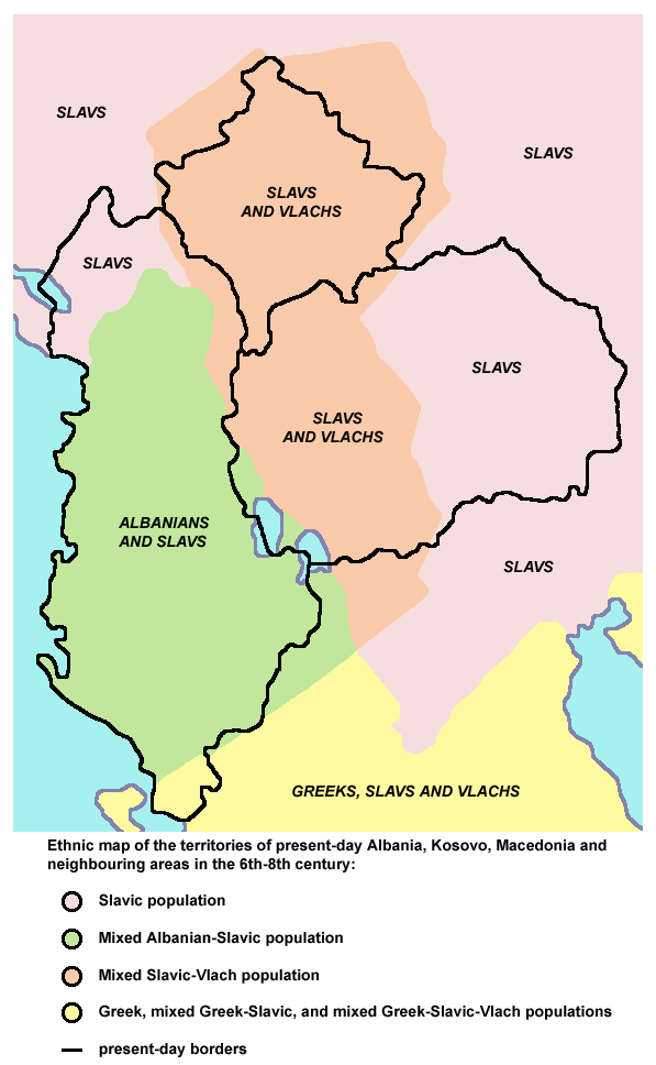
English: Ethnic map of the territories of present-day Albania, Kosovo, Macedonia and neighbouring areas in the 6th-8th century (according to the historical atlas for schools, published in Belgrade in 1970, representing a view of Yugoslav historians from that time). |
| Izvor | Vlastito djelo postavljača |
| Autor | PANONIAN |
Licencija
| Ja, nositelj autorskog prava za ovo djelo, prepuštam ovo djelo u javno vlasništvo. Ovo prepuštanje vrijedi za cijeli svijet. U nekim državama to nije pravno moguće; ako je tako: Dajem svima prava da koriste ovo djelo za bilo koju svrhu, bez ikakvih uvjeta, osim ako takvi uvjeti nisu propisani zakonom. |
References
Main reference:
- Created according to the historical map from this history atlas: "Školski istorijski atlas, Zavod za izdavanje udžbenika SR Srbije, Beograd, 1970."
Secondary references (with similar maps):
- The Times - Atlas Svjetske Povijesti, Dopunjeno izdanje za Jugoslaviju, Cankarjeva založba, Ljubljana, 1986. - this is Yugoslav (Serbo-Croatian) edition of this original source: The Times Atlas of World History, Times Books Limited, London, 1984. (in Yugoslav version from 1986 there is similar map on page number 298)
- Denis Šehić - Demir Šehić, Istorijski atlas Sveta, Beograd, 2007. (similar map is published on page number 29)
- Istorijski atlas, Geokarta, Beograd, 1999. (similar map is published on page number 33)
- The former Yugoslavia's diverse peoples: a reference sourcebook By Matjaž Klemenčič, Mitja Žagar: https://books.google.com/books?id=ORSMBFwjAKcC&pg=PA3&lpg=PA5&vq=maps&output=html (a source with similar map published on page number 3)
- Here is an external link with similar map: http://www.camo.ch/illiricum7.htm archive copy at the Wayback Machine
Povijest datoteke
Kliknite na datum/vrijeme kako biste vidjeli datoteku kakva je tada bila.
| Datum/Vrijeme | Minijatura | Dimenzije | Suradnik | Komentar | |
|---|---|---|---|---|---|
| sadašnja | 22:27, 21. rujna 2013. | | 597 × 968 (55 KB) | PANONIAN | aesthetics |
| 20:56, 7. veljače 2010. |  | 598 × 964 (55 KB) | PANONIAN | {{Information |Description={{en|1=Ethnic map of the territories of present-day Albania, Kosovo, Macedonia and neighbouring areas in the 6th-8th century.}} |Source={{own}} |Author=PANONIAN |Date= |Permission= |other_versions= }} |
Uporaba datoteke
Na ovu sliku vode poveznice sa sljedećih stranica:
Globalna uporaba datoteke
Sljedeći wikiji rabe ovu datoteku:
- Uporaba na hu.wikipedia.org
- Uporaba na mk.wikipedia.org
- Uporaba na pl.wikipedia.org
- Uporaba na sr.wikipedia.org