
Datoteka:1801 Cary Map of Austria - Geographicus - Austria-cary-1801.jpg

Veličina ovog prikaza: 668 × 600 piksela. Ostale razlučivosti: 267 × 240 piksela | 535 × 480 piksela | 856 × 768 piksela | 1.141 × 1.024 piksela | 2.282 × 2.048 piksela | 5.000 × 4.488 piksela.
Vidi sliku u punoj veličini (5.000 × 4.488 piksela, veličina datoteke: 7,86 MB, MIME tip: image/jpeg)
| Ova je datoteka sa Zajedničkog poslužitelja i mogu je rabiti drugi projekti. Opis s njezine stranice s opisom datoteke prikazan je ispod. |
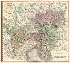
| John Cary: A New Map of the Circle of Austria, from the Latest Authorities.
( |
||||||||||||||||||||||||||
|---|---|---|---|---|---|---|---|---|---|---|---|---|---|---|---|---|---|---|---|---|---|---|---|---|---|---|
| Umjetnik/stvaratelj |
|
|||||||||||||||||||||||||
| Naziv |
A New Map of the Circle of Austria, from the Latest Authorities. |
|||||||||||||||||||||||||
| Opis |
English: An extremely attractive example of John Cary’s important 1801 map of the Austria. Covers from Lake Constance eastward as far as Lake Pelso and the Hungarian border. Extends southward to include the Duchy of Tyrol, the Republic of Venice and the Gulf of Venice. Extends northward as far as Bavaria, Bohemia and Moravia. Offers stupendous detail and color coding according to region. All in all, one of the most interesting and attractive atlas maps the Austrian Empire to appear in first years of the 19th century. Prepared in 1801 by John Cary for issue in his magnificent 1808 New Universal Atlas . |
|||||||||||||||||||||||||
| Datum | 1801 (dated) | |||||||||||||||||||||||||
| Dimenzije | visina: 18 in (45,7 cm); Širina: 20,5 in (52 cm) | |||||||||||||||||||||||||
| Inventarni broj |
Geographicus link: Austria-cary-1801 |
|||||||||||||||||||||||||
| Izvor/fotograf |
Cary, John, Cary's New Universal Atlas, containing distinct maps of all the principal states and kingdoms throughout the World. From the latest and best authorities extant. London: Printed for J. Cary, Engraver and Map-seller, No. 181, near Norfolk Street, Strand, 1808.
|
|||||||||||||||||||||||||
| Dopuštenje (Naknadna uporaba ove datoteke) |
|
|||||||||||||||||||||||||
Povijest datoteke
Kliknite na datum/vrijeme kako biste vidjeli datoteku kakva je tada bila.
| Datum/Vrijeme | Minijatura | Dimenzije | Suradnik | Komentar | |
|---|---|---|---|---|---|
| sadašnja | 13:10, 22. ožujka 2011. | | 5.000 × 4.488 (7,86 MB) | BotMultichillT | {{subst:User:Multichill/Geographicus |link=http://www.geographicus.com/P/AntiqueMap/Austria-cary-1801 |product_name=1801 Cary Map of Austria |map_title=A New Map of the Circle of Austria, from the Latest Authorities. |description=An extremely attractive e |
Uporaba datoteke
Na ovu sliku vode poveznice sa sljedećih stranica:
Globalna uporaba datoteke
Sljedeći wikiji rabe ovu datoteku:
- Uporaba na fr.wikipedia.org
- Uporaba na sh.wikipedia.org