
Datoteka:EU Balkan enlargement.svg

Veličina ovog PNG prikaza ove SVG datoteke: 680 × 520 piksela. Ostale razlučivosti: 314 × 240 piksela | 628 × 480 piksela | 1.004 × 768 piksela | 1.280 × 979 piksela | 2.560 × 1.958 piksela.
Vidi sliku u punoj veličini (SVG datoteka, nominalno 680 × 520 piksela, veličina datoteke: 601 KB)
| Ova je datoteka sa Zajedničkog poslužitelja i mogu je rabiti drugi projekti. Opis s njezine stranice s opisom datoteke prikazan je ispod. |
Sažetak
| Opis |
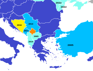
English (en): A map of the European Union potential candidate states in the Balkans, with the date of the latest step in the process.
Member states Candidates negotiating membership Candidates Potential candidates which have submitted a membership application Potential candidates which have not submitted a membership application
español (es): Estado actual de las candidaturas para la adhesión a la Unión Europea
Estados miembros. Candidatos oficiales negociando las condiciones de adhesión. Candidatos oficiales que aún no han comenzado a negociar. Candidatos potenciales que han presentado la candidatura. Candidatos potenciales que no han presentado candidatura.
|
| Datum | (UTC) |
| Izvor | No machine-readable source is provided. Blank map of Europe.svg is assumed. |
| Autor |
|
| Ovo je retuširana slika, što znači da je digitalno izmjenjena u odnosu na svoju izvornu inačicu. Izmjene: crop and colour. Izvornik se može vidjeti ovdje: Blank map of Europe.svg. Izmjene je napravio: Danlaycock.
|
Licencija
Ja, nositelj autorskog prava za ovo djelo, ovime ga objavljujem pod sljedećom licencijom:
Ova datoteka je licencirana pod Creative Commons Imenovanje-Dijeli pod istim uvjetima 2.5 nelokaliziranom licencijom.
- Slobodno smijete:
- dijeliti – umnožavati, distribuirati i javnosti priopćavati djelo
- remiksirati – prerađivati djelo
- Pod sljedećim uvjetima:
- imenovanje autora – Morate pripisati odgovarajuće autorske zasluge, dati poveznicu na licenciju, te naznačiti jesu li načinjene promjene autorskog djela. Prethodno navedeno možete učiniti na svaki razuman način, ali ne na način koji bi sugerirao da Vi ili Vaše korištenje licencorova djela ima izravno licencorovo odobrenje.
- dijeli pod istim uvjetima – Ako ovo djelo izmijenite, preoblikujete ili stvarate na osnovu tog materijala, svoje doprinose morate distribuirati pod istom ili kompatibilnom licencijom kao što je i licencija originala.
Izvorna evidencija postavljanja
This image is a derivative work of the following images:
- File:Blank_map_of_Europe.svg licensed with Cc-by-sa-2.5
- 2012-02-21T16:27:27Z Alphathon 680x520 (614699 Bytes) Updated Metadata and the boarders/coastlines along the western coast of the Black Sea
- 2011-09-19T22:57:58Z Alphathon 680x520 (603759 Bytes) Added North/Northern Cyprus
- 2011-08-23T10:26:48Z Heb 680x520 (604212 Bytes) Added [[:en:Bornholm]] (taken from [[:File:Denmark blank map.svg]])
- 2011-04-12T00:40:40Z Alphathon 680x520 (602549 Bytes) Upgraded Sicily based on "File:Freeworldmaps-sicily.jpg". Upgraded Malta based on "File:Map of Malta 2.png". Simplified Croatian borders.
- 2011-04-10T21:43:04Z Alphathon 680x520 (607359 Bytes) Upgraded Croatia, Bosnia & Herzegovina, Slovenia and surrounding countries based on data from "File:Kroatien - Politische Gliederung (Karte).png"
- 2011-04-10T20:05:09Z Alphathon 680x520 (568373 Bytes) Improved Serbia, Montenegro and surrounding countries using data from "File:Serbia Map.png". Fixed Serbia-Montenegro border. Added Kosovo (using dashed border, since it is not a universally recognised nation, and left the lan
- 2011-04-10T15:55:02Z Alphathon 680x520 (524980 Bytes) Tweaked Ukraine and surrounding countries based on data from "File:Up-map.png"
- 2011-04-10T04:02:09Z Alphathon 680x520 (511168 Bytes) Improved Greece, Albania, F.Y.R. Macedonia and Bulgaria based on "File:Greece topo.jpg"
- 2011-04-10T02:48:52Z Alphathon 680x520 (505569 Bytes) Tweaked Germany and surrounding countries based on info from "File:Germany_general_map.png"
- 2011-04-10T01:54:05Z Alphathon 680x520 (493733 Bytes) Converted all lakes back to separate layer. Added Finish lakes and tweaked Finland shape based on "File:Finland 1996 CIA map.jpg". Added Swiss lakes based on "File:Suisse cantons.svg". Tweaked Scotland and added Lochs.
- 2011-04-10T00:07:54Z Alphathon 680x520 (450120 Bytes) Improved England outline and added Isle of Wight based on "File:England Regions - Blank.svg". Improved Denmark based on "File:2 digit postcode danmark.png". Improved Sweden based on "File:Map of Sweden, CIA, 1996.jpg"
- 2011-04-08T15:53:07Z Alphathon 680x520 (438878 Bytes) Upgraded/fixed various parts of the map. Details: *Some minor fixes to Ireland and added some of the larger lakes based on [[:File:Ireland_trad_counties_named.svg]] *Pretty major fixes to Scotland (mainly the west coast and i
- 2008-09-17T09:50:25Z F7 680x520 (531491 Bytes)
- 2008-09-17T09:42:57Z F7 680x520 (2353 Bytes)
- 2008-05-26T19:04:07Z Collard 680x520 (531491 Bytes) uploading on behalf of [[User:Checkit]], direct complaints to him plox: 'Moved countries out of the "outlines" group, removed "outlines" style class, remove separate style information for Russia'
- 2008-04-30T01:38:52Z TimothyBourke 680x520 (531767 Bytes) Changed the country code of Serbia to RS per [http://en.wikipedia.org/wiki/Serbian_country_codes] and the file [http://www.iso.org/iso/iso3166_en_code_lists.txt].
- 2008-02-08T22:44:37Z CarolSpears 680x520 (531767 Bytes) validated
- 2007-07-10T11:47:59Z MrWeeble 680x520 (533112 Bytes) Updated to include British Crown Dependencies as seperate entities and regroup them as "British Islands", with some simplifications to the XML and CSS
- 2007-05-14T17:17:34Z Zirland 680x520 (540659 Bytes) serbia and montenegro
- 2007-03-30T20:40:49Z W!B: 680x520 (538830 Bytes) minor corr: update nl:Ijsselmeer, del fi:lakes (all small), add ru:lake Oneka (all ref maps.google), glued northern irland back to ie ;)
- 2007-02-05T18:44:32Z Maix 680x520 (538295 Bytes) cropped
- 2007-02-04T15:07:29Z Maix 680x520 (538310 Bytes) {{Information |Description=A blank Map of Europe in SVG format. Every country has an id which is its ISO-3116-1-ALPHA2 code in lower case for easy coloring. |Source=Image based on [[Image:Europe_countries.svg|]] by [[User:Ti
Uploaded with derivativeFX
Povijest datoteke
Kliknite na datum/vrijeme kako biste vidjeli datoteku kakva je tada bila.
| Datum/Vrijeme | Minijatura | Dimenzije | Suradnik | Komentar | |
|---|---|---|---|---|---|
| sadašnja | 18:04, 26. lipnja 2022. | | 680 × 520 (601 KB) | Danlaycock | update ukraine and moldova, also albania and macedonia never started negotiations |
| 11:13, 12. ožujka 2022. |  | 680 × 520 (601 KB) | Sbb1413 | Ukraine and Moldova. | |
| 06:39, 30. ožujka 2020. |  | 680 × 520 (601 KB) | Danlaycock | update .al .mk | |
| 08:09, 7. lipnja 2018. |  | 680 × 520 (601 KB) | Forthrunner | Malta | |
| 03:06, 12. prosinca 2017. |  | 680 × 520 (601 KB) | Danlaycock | rm date the relevance of which is not described | |
| 08:51, 10. prosinca 2017. |  | 680 × 520 (601 KB) | Concus Cretus | color scheme matching File:Further European Union Enlargement.svg | |
| 16:33, 15. veljače 2016. |  | 680 × 520 (600 KB) | Danlaycock | update .ba | |
| 21:34, 27. lipnja 2014. |  | 680 × 520 (600 KB) | Lonaowna | Reverted to version as of 19:23, 27 June 2014 (beat me by 10 mins) | |
| 21:33, 27. lipnja 2014. |  | 680 × 520 (600 KB) | Lonaowna | update Albania: is now a candidate | |
| 21:23, 27. lipnja 2014. |  | 680 × 520 (600 KB) | Danlaycock | update albania |
Uporaba datoteke
Na ovu sliku vode poveznice sa sljedećih stranica:
Globalna uporaba datoteke
Sljedeći wikiji rabe ovu datoteku:
- Uporaba na en.wikipedia.org
- Uporaba na et.wikipedia.org
- Uporaba na hy.wikipedia.org
- Uporaba na uk.wikipedia.org