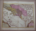
Datoteka:Historical map of Dalmatia and surroundings.jpg

Stranica ne postoji na drugim jezicima.
Izvor: Wikipedija

Vidi sliku u punoj veličini(1.311 × 1.110 piksela, veličina datoteke: 238 KB, MIME tip: image/jpeg)


Logo Wikimedijinog spremnika Ova je datoteka sa Zajedničkog poslužitelja i mogu je rabiti drugi projekti. Opis s njezine stranice s opisom datoteke prikazan je ispod.
Opis
Bosanski: Geografska karta Dalmacije i Bosne. Ručna izradba. Dimenzije: 53,5 × 63
Deutsch: Geographische Karte von Dalmatien und Bosnien. Dimensionen: 53,5 × 63
English: Geographic map of Dalmatia and Bosnia; Handmade; Dimensions: 53.5 × 63
Datum Before Ottoman Empire conquered these lands.
Izvor Historical Archive Sarajevo - Website
Autor
Bosanski: Crtao P. Coronelli - geograf iz Venecije.
Deutsch: Die Karte wurde von Geographen P. Coronelli aus Venedig handgezeichnet.
English: Drawn by P. Coronelli – geographer from Venice
Dopuštenje
(Naknadna uporaba ove datoteke)
This is a faithful photographic reproduction of a two-dimensional, public domain work of art. The work of art itself is in the public domain for the following reason:
Public domain

Ovo je djelo u javnom vlasništvu u zemlji podrijetla i u drugim zemljama s rokom trajanja autorskih prava za života autora plus 70 godina ili manje.


Morate dodati i oznaku javnog vlasništva za Sjedinjene Američke Države da bi se naznačilo zašto je ovo djelo u javnom vlasništvu u Sjedinjenim Američkim Državama. Note that a few countries have copyright terms longer than 70 years: Mexico has 100 years, Jamaica has 95 years, Colombia has 80 years, and Guatemala and Samoa have 75 years. This image may not be in the public domain in these countries, which moreover do not implement the rule of the shorter term. Honduras has a general copyright term of 75 years, but it does implement the rule of the shorter term. Copyright may extend on works created by French who died for France in World War II (more information), Russians who served in the Eastern Front of World War II (known as the Great Patriotic War in Russia) and posthumously rehabilitated victims of Soviet repressions (more information).

The official position taken by the Wikimedia Foundation is that "faithful reproductions of two-dimensional public domain works of art are public domain".
This photographic reproduction is therefore also considered to be in the public domain in the United States. In other jurisdictions, re-use of this content may be restricted; see Reuse of PD-Art photographs for details.
Ostale inačice Orriginal stored under the code ZKP-280-61

Povijest datoteke

Kliknite na datum/vrijeme kako biste vidjeli datoteku kakva je tada bila.

Datum/VrijemeMinijaturaDimenzijeSuradnikKomentar
sadašnja02:37, 17. svibnja 2007.Minijatura za inačicu od 02:37, 17. svibnja 2007.1.311 × 1.110 (238 KB)Rainman~commonswiki{{Information |Description={{bs|Geografska karta Dalmacije i Bosne. Ručna izradba. Dimenzije: 53,5 × 63}} {{de|Geographische Karte von Dalmatien und Bosnien. Dimensionen: 53,5 × 63}} {{en|Geographic map of Dalmatia and Bosnia; Handmade; Dimensions: 53.

Na ovu sliku vode poveznice sa sljedećih stranica:

Globalna uporaba datoteke

Sljedeći wikiji rabe ovu datoteku:

Metapodatci