
Datoteka:Lage des Landkreises Uckermark in Deutschland.png
Viša rezolucija nije dostupna.
Lage_des_Landkreises_Uckermark_in_Deutschland.png (176 × 234 piksela, veličina datoteke: 5 KB, MIME tip: image/png)
| Ova je datoteka sa Zajedničkog poslužitelja i mogu je rabiti drugi projekti. Opis s njezine stranice s opisom datoteke prikazan je ispod. |
Sažetak
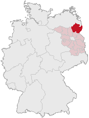
Karte erstellt auf der Grundlage der opengeodb.de-Umrisse.
Moved from de.wikipedia.org, first upload by de:Benutzer:Geograv.
Licencija
This image was generated with OpenGeoDB. The information there is placed in the public domain, images generated from OpenGeoDB are derivative works without passing the threshold of creativity, they are therefore also public domain.
| This work is ineligible for copyright and therefore in the public domain because it consists entirely of information that is common property and contains no original authorship. |
Povijest datoteke
Kliknite na datum/vrijeme kako biste vidjeli datoteku kakva je tada bila.
| Datum/Vrijeme | Minijatura | Dimenzije | Suradnik | Komentar | |
|---|---|---|---|---|---|
| sadašnja | 02:23, 18. lipnja 2006. | | 176 × 234 (5 KB) | Rauenstein | == Summary == Karte erstellt auf der Grundlage der opengeodb.de-Umrisse. Moved from de.wikipedia.org, first upload by de:Benutzer:Geograv. == License == {{GFDL-OpenGeoDB}} Category:Maps of Brandenburg |
Uporaba datoteke
Na ovu sliku vode poveznice sa sljedećih stranica:
Globalna uporaba datoteke
Sljedeći wikiji rabe ovu datoteku:
- Uporaba na da.wikipedia.org
- Uporaba na de.wikipedia.org
- Uporaba na fr.wikipedia.org
- Uporaba na hy.wikipedia.org
- Uporaba na id.wikipedia.org
- Uporaba na ka.wikipedia.org
- Uporaba na kk.wikipedia.org
- Uporaba na pl.wikipedia.org
- Uporaba na sh.wikipedia.org
- Uporaba na sr.wikipedia.org
- Uporaba na sv.wikipedia.org
- Uporaba na uk.wikipedia.org