
Datoteka:Lake District National Park UK relief location map.png
Veličina ovog prikaza: 494 × 600 piksela. Ostale razlučivosti: 198 × 240 piksela | 395 × 480 piksela | 632 × 768 piksela | 843 × 1.024 piksela | 2.001 × 2.430 piksela.
Vidi sliku u punoj veličini (2.001 × 2.430 piksela, veličina datoteke: 3,62 MB, MIME tip: image/png)
| Ova je datoteka sa Zajedničkog poslužitelja i mogu je rabiti drugi projekti. Opis s njezine stranice s opisom datoteke prikazan je ispod. |
| Opis |
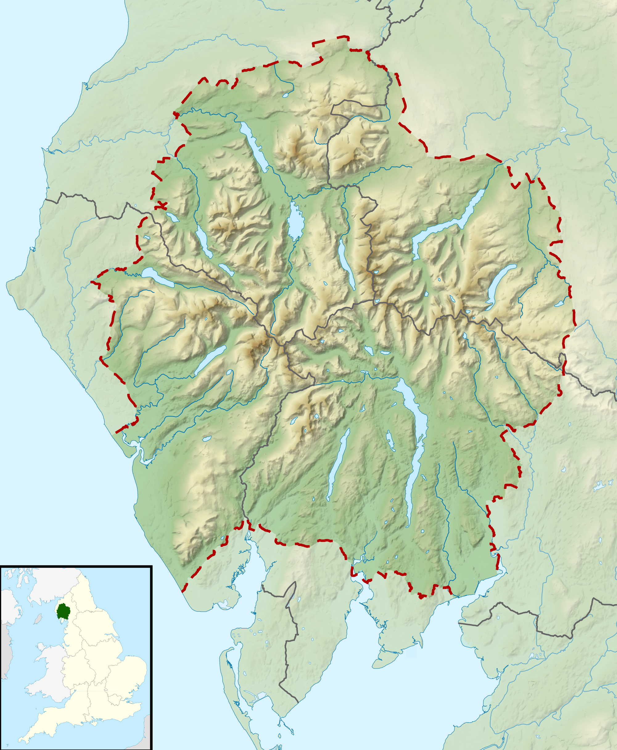
Relief map of the Lake District National Park, UK Equirectangular map projection on WGS 84 datum, with N/S stretched 170% Geographic limits:
|
| Datum | |
| Izvor |
Office of National Statistics Geography
|
| Autor | Nilfanion, created using Ordnance Survey data |
| Dopuštenje (Naknadna uporaba ove datoteke) |
Ova datoteka je licencirana pod Creative Commons Imenovanje-Dijeli pod istim uvjetima 3.0 nelokaliziranom licencijom. Autor: Contains Ordnance Survey data © Crown copyright and database right
|
Povijest datoteke
Kliknite na datum/vrijeme kako biste vidjeli datoteku kakva je tada bila.
| Datum/Vrijeme | Minijatura | Dimenzije | Suradnik | Komentar | |
|---|---|---|---|---|---|
| sadašnja | 12:51, 17. ožujka 2012. | | 2.001 × 2.430 (3,62 MB) | Nilfanion | {{Information |Description=Relief map of the Lake District National Park, UK Equirectangular map projection on WGS 84 datum, with N/S stretched 170% Geographic limits: *West: 3.65W *East: 2.60W *North: 54.80N *South: 54.05N |Sourc... |
Uporaba datoteke
Na ovu sliku vode poveznice sa sljedećih stranica:
Globalna uporaba datoteke
Sljedeći wikiji rabe ovu datoteku:
- Uporaba na ar.wikipedia.org
- Uporaba na ceb.wikipedia.org
- Uporaba na de.wikivoyage.org
- Uporaba na en.wikipedia.org
- Lake District
- Derwentwater
- Scafell Pike
- Windermere
- Coniston Water
- Scafell
- Helvellyn
- Wast Water
- Thirlmere
- Skiddaw
- List of lakes of the Lake District
- Bassenthwaite Lake
- Ullswater
- Buttermere
- Old Man of Coniston
- Dent (fell)
- Pillar (Lake District)
- Great Gable
- Bowfell
- Fairfield (Lake District)
- Great End
- Catstye Cam
- Blencathra
- Skiddaw Little Man
- Crinkle Crags
- Haweswater Reservoir
- Ennerdale Water
- Castlerigg stone circle
- Hard Knott
- Harter Fell (Eskdale)
- Whitbarrow
- Great Dodd
- High Street (Lake District)
- Pavey Ark
- Dale Head
- Robinson (Lake District)
- Place Fell
- Little Mell Fell
- Grayrigg Forest
- Hallin Fell
- Grasmoor
- Cold Pike
- Gummer's How
- Whitfell
- High Raise (Langdale)
- Kirkby Moor
- Cat Bells
Pogledajte globalnu uporabu ove datoteke.