
Datoteka:Le Castellet circuit map Formula One 2018 without corner names English 29 06 2021.svg

Veličina ovog PNG prikaza ove SVG datoteke: 673 × 599 piksela. Ostale razlučivosti: 270 × 240 piksela | 539 × 480 piksela | 863 × 768 piksela | 1.150 × 1.024 piksela | 2.300 × 2.048 piksela | 2.191 × 1.951 piksela.
Vidi sliku u punoj veličini (SVG datoteka, nominalno 2.191 × 1.951 piksela, veličina datoteke: 59 KB)
| Ova je datoteka sa Zajedničkog poslužitelja i mogu je rabiti drugi projekti. Opis s njezine stranice s opisom datoteke prikazan je ispod. |
Sažetak
| Opis |
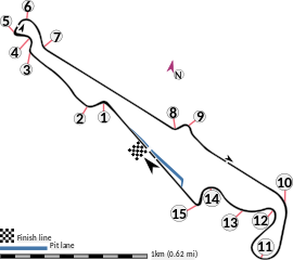
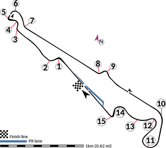
English: This is an altered version of File:Le Castellet circuit map Formula One 2018 without corner names June 2021.svg with the key solely in English and a few other alterations. This is a map of the Le Castellet motor circuit as it was used by w:en:Formula One for the w:en:2018 French Grand Prix, before the pit lane entrances and exits were reconfigured, and includes corner numbers and other information sourced from the FIA's map of the circuit. This map is valid for races which use this layout and corner numbering scheme, please upload a new file for races which use different layouts or corner numbering schemes rather than replacing this file. As this is a free-hand map drawn by an enthusiast rather than a professional cartographer's work it may contain some errors, although checking it against other maps it appears accurate enough for most purposes. The track is shown in black with a grey outline, while the pit lane is shown in blue. A scale showing the length of one kilometre (with increments of 100 metres) is given, to allow viewers to contextualise and understand what they are looking at. Corner numbers and other important text is given an off-white background to avoid transparency issues rendering it illegible on certain devices. A thick white line covering the track and the pit lane, marked with a chequered flag, shows the location of the start/finish line, also known as the control or timing line. A thinner white line, covering only the track, shows the location of pole position, and is marked with a large black arrow indicating the direction of travel. There are also thin white lines crossing the track which indicate the ends of the first and second timing sectors used by Formula One; these are marked with smaller black arrows, which also indicate the direction of travel. The mauve arrow marked "N" shows the direction of north.
Arrow pointing north Pit lane Links corner number to location of corner |
| Datum | |
| Izvor | Vlastito djelo postavljača |
| Autor | HumanBodyPiloter5 |
| Ostale inačice |
   |
Licencija
Ja, nositelj autorskog prava za ovo djelo, ovime ga objavljujem pod sljedećom licencijom:
| Ova datoteka je dostupna pod Creative Commons CC0 univerzalnim odricanjem u javno vlasništvo. | |
| Osoba koja je sudjelovala u radu na ovom dokumentu posvetila je rad javnom vlasništvu odricanjem od svih njenih prava na taj rad širom svijeta po zakonom o autorskim pravima i sve povezana zakonska prava koja bi imao/imala, u mjeri dopuštenoj zakonom. Možete kopirati, mijenjati, distribuirati i prilagođavati rad, čak i u komercijalne svrhe, bez traženja dopuštenja.
|
Povijest datoteke
Kliknite na datum/vrijeme kako biste vidjeli datoteku kakva je tada bila.
| Datum/Vrijeme | Minijatura | Dimenzije | Suradnik | Komentar | |
|---|---|---|---|---|---|
| sadašnja | 03:15, 29. lipnja 2021. | | 2.191 × 1.951 (59 KB) | HumanBodyPiloter5 | Uploaded own work with UploadWizard |
Uporaba datoteke
Na ovu sliku vode poveznice sa sljedećih stranica:
Globalna uporaba datoteke
Sljedeći wikiji rabe ovu datoteku:
- Uporaba na af.wikipedia.org
- Uporaba na en.wikipedia.org
- Uporaba na fi.wikipedia.org
- Uporaba na fr.wikipedia.org
- Uporaba na fy.wikipedia.org
- Uporaba na gl.wikipedia.org
- Uporaba na hu.wikipedia.org
- Uporaba na id.wikipedia.org
- Uporaba na it.wikipedia.org
- Uporaba na pl.wikipedia.org
- Uporaba na ro.wikipedia.org
- Uporaba na tr.wikipedia.org