
Datoteka:Persia 1814.jpg
Veličina ovog prikaza: 718 × 600 piksela. Ostale razlučivosti: 287 × 240 piksela | 575 × 480 piksela | 920 × 768 piksela | 1.226 × 1.024 piksela | 2.452 × 2.048 piksela | 2.931 × 2.448 piksela.
Vidi sliku u punoj veličini (2.931 × 2.448 piksela, veličina datoteke: 1,6 MB, MIME tip: image/jpeg)
| Ova je datoteka sa Zajedničkog poslužitelja i mogu je rabiti drugi projekti. Opis s njezine stranice s opisom datoteke prikazan je ispod. |
Sažetak
| Descripcion |
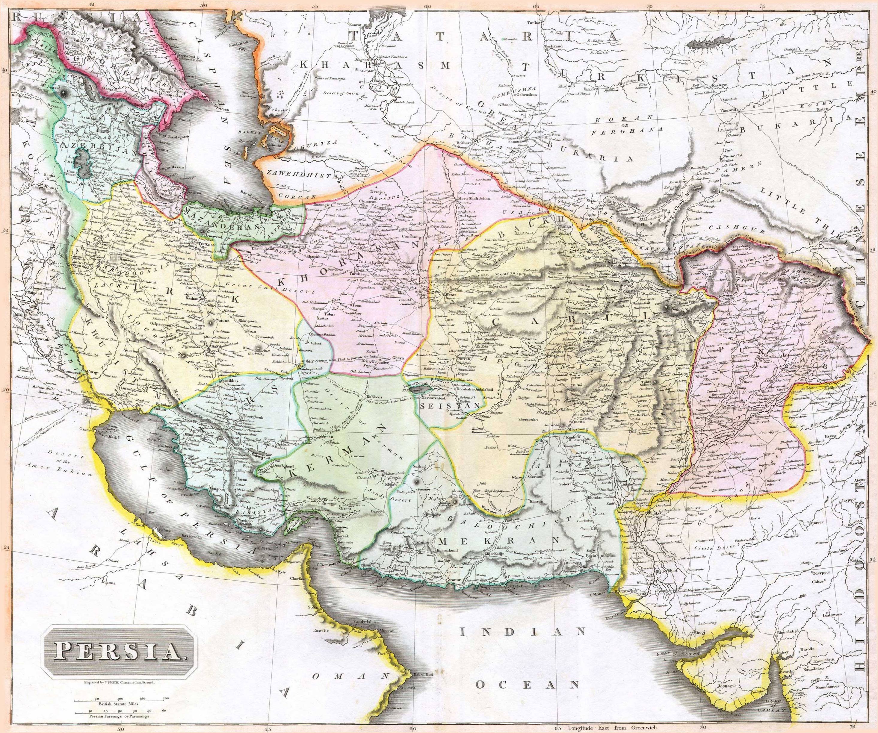
English: 1814 Thomson Map of Persia (Iran), engraved by J. Smith, Clement's Inn, Strand. |
| Datum | |
| Stvaratelj |
J. Smith, Clement's Inn, Strand. |
| Geotemporal data | |
| Map location | Iran |
| Georeferencing | If inappropriate please set warp_status = skip to hide. |
| Bibliographic data | |
| Publikacija |
New General Atlas (1821) |
| Autor |
John Thomson |
| Ostale inačice | |

Licencija
The copyright situation of this work is theoretically uncertain, because in the country of origin copyright lasts 70 years after the death of the author, and the date of the author's death is unknown. However, the date of creation of the work was over 120 years ago, and it is thus a reasonable assumption that the copyright has expired (see here for the community discussion). Do not use this template if the date of death of the author is known.
Ovo je djelo u javnom vlasništvu u SAD-u zato jer je objavljeno (ili registrirano pri Uredu za autorska prava Sjedinjenih Američkih Država) prije 1. siječnja 1929. | |
| Ova datoteka je identificirana kao slobodna od poznatih ograničenja po zakonu o autorskim pravima, uključujući sva povezana i srodna prava. | |
Povijest datoteke
Kliknite na datum/vrijeme kako biste vidjeli datoteku kakva je tada bila.
| Datum/Vrijeme | Minijatura | Dimenzije | Suradnik | Komentar | |
|---|---|---|---|---|---|
| sadašnja | 09:27, 18. kolovoza 2010. | | 2.931 × 2.448 (1,6 MB) | Begoon | edge perspective and crop |
| 04:35, 19. studenoga 2006. |  | 2.979 × 2.520 (1,45 MB) | Kaveh | == Summary == 1814 Thomson Map of Persia (Iran) Category:Maps of Iran == Licensing == {{PD-old}} |
Uporaba datoteke
Na ovu sliku vode poveznice sa sljedećih stranica:
Globalna uporaba datoteke
Sljedeći wikiji rabe ovu datoteku:
- Uporaba na ar.wikipedia.org
- Uporaba na az.wikipedia.org
- Uporaba na be.wikipedia.org
- Uporaba na bn.wikipedia.org
- Uporaba na bs.wikipedia.org
- Uporaba na ca.wikipedia.org
- Uporaba na da.wikipedia.org
- Uporaba na de.wikipedia.org
- Uporaba na en.wikipedia.org
- Uporaba na es.wikipedia.org
- Uporaba na eu.wikipedia.org
- Uporaba na fa.wikipedia.org
- Uporaba na fr.wikipedia.org
- Uporaba na hi.wikipedia.org
- Uporaba na hu.wikipedia.org
- Uporaba na hy.wikipedia.org
Pogledajte globalnu uporabu ove datoteke.