
Datoteka:Rb-map.png
Rb-map.png (328 × 352 piksela, veličina datoteke: 13 KB, MIME tip: image/png)
| Ova je datoteka sa Zajedničkog poslužitelja i mogu je rabiti drugi projekti. Opis s njezine stranice s opisom datoteke prikazan je ispod. |
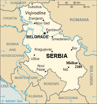
| Opis | Map of the Republic of Serbia (FIPS 10 country code standard: RB) | |||
| Datum | ||||
| Izvor | The World Factbook (published by CIA in 2008). | |||
| Autor | Central Intelligence Agency of the Government of the United States of America | |||
| Dopuštenje (Naknadna uporaba ove datoteke) |
|
|||
| Ostale inačice | Recommend that Image:Sr-map.png should be deleted and Image:Serbia-CIA WFB Map.png should be spared to show how the map looked before 2008. |
Sažetak
Map of Serbia from The World Factbook archive copy at the Wayback Machine (published by CIA in 2008).
This map is updated with current events; independence of Kosovo and certain faults like BUL. is replaced with BULGARIA. The name of the country is in bold font, like the name of the Autonomous Province of Vojvodina (Northern Serbian province). Also the highest mountain in Serbia (Central Serbia region) is marked at the border with Bulgaria with the name of that peak - Midžor - and added the height in meters.
The name of the file
The National Geospatial-Intelligence Agency maintains the FIPS 10 country code standard that US Government use.
On 2006-07-11 the following changes have been made:
DELETE the following geopolitical entities and codes:
- YI SERBIA AND MONTENEGRO
- YI01 Crna Gora (Montenegro)
- YI02 Srbija (Serbia)
ADD the following geopolitical entity and code:
- MJ MONTENEGRO
ADD the following geopolitical entity and code:
- RB SERBIA
The notice was issued by:
Randall E. Flynn
Geographer
National Geospatial-Intelligence Agency
GEOnet Names Server at this web-site.
Recommend that Image:Sr-map.png should be deleted and Image:Serbia-CIA WFB Map.png should be spared to show how the map looked before 2008.
Licencija
Ova je slika u javnom vlasništvu jer sadrži materijale iz World Factbooka u izdanju američke Središnje obavještajne agencije (CIA).
|
 |
For enhancements
| Ja, nositelj autorskog prava za ovo djelo, prepuštam ovo djelo u javno vlasništvo. Ovo prepuštanje vrijedi za cijeli svijet. U nekim državama to nije pravno moguće; ako je tako: Dajem svima prava da koriste ovo djelo za bilo koju svrhu, bez ikakvih uvjeta, osim ako takvi uvjeti nisu propisani zakonom. |
Povijest datoteke
Kliknite na datum/vrijeme kako biste vidjeli datoteku kakva je tada bila.
| Datum/Vrijeme | Minijatura | Dimenzije | Suradnik | Komentar | |
|---|---|---|---|---|---|
| sadašnja | 23:22, 15. siječnja 2014. | | 328 × 352 (13 KB) | Denniss | Reverted to version as of 19:30, 14 February 2008 |
| 23:13, 15. siječnja 2014. |  | 328 × 352 (36 KB) | Ivan VA | updating borders | |
| 23:12, 15. siječnja 2014. |  | 328 × 352 (36 KB) | Ivan VA | vandalizm | |
| 00:29, 3. siječnja 2014. |  | 328 × 352 (13 KB) | No More Cats | oops, I got the wrong version | |
| 18:11, 2. siječnja 2014. |  | 328 × 352 (13 KB) | No More Cats | Reverted to version as of 12:25, 28 February 2011 - original CIA map | |
| 15:53, 8. kolovoza 2013. |  | 328 × 352 (36 KB) | Pokrajac | Reverted to version as of 21:00, 11 February 2011 | |
| 14:25, 28. veljače 2011. |  | 328 × 352 (13 KB) | IJA | Reverted to version as of 19:30, 14 February 2008 | |
| 23:00, 11. veljače 2011. |  | 328 × 352 (36 KB) | Pokrajac | {{Information |Description=Map of the Republic of Serbia (FIPS 10 country code standard: RB) |Source=[https://www.cia.gov/library/publications/the-world-factbook/geos/rb.html The World Factbook] (published by CIA in 2008). |Date=2008-02-28 |Author=Central | |
| 21:30, 14. veljače 2008. |  | 328 × 352 (13 KB) | Imbris~commonswiki | {{Information |Description=Map of the Republic of Serbia (FIPS 10 country code standard: RB) |Source=[https://www.cia.gov/library/publications/the-world-factbook/geos/rb.html The World Factbook] (published by CIA in 2008). |Date=2008-06-15 |Author=Central |
Uporaba datoteke
Nijedna stranica ne rabi ovu datoteku.
Globalna uporaba datoteke
Sljedeći wikiji rabe ovu datoteku:
- Uporaba na de.wikipedia.org
- Uporaba na eo.wikipedia.org
- Uporaba na he.wikipedia.org
- Uporaba na nl.wiktionary.org
- Uporaba na to.wikipedia.org