
Datoteka:1750 Bellin Map of the Senegal - Geographicus - Senegal-bellin-1750.jpg

Veličina ovog prikaza: 427 × 599 piksela. Ostale razlučivosti: 171 × 240 piksela | 342 × 480 piksela | 547 × 768 piksela | 730 × 1.024 piksela | 1.985 × 2.784 piksela.
Vidi sliku u punoj veličini (1.985 × 2.784 piksela, veličina datoteke: 1,13 MB, MIME tip: image/jpeg)
| Ova je datoteka sa Zajedničkog poslužitelja i mogu je rabiti drugi projekti. Opis s njezine stranice s opisom datoteke prikazan je ispod. |
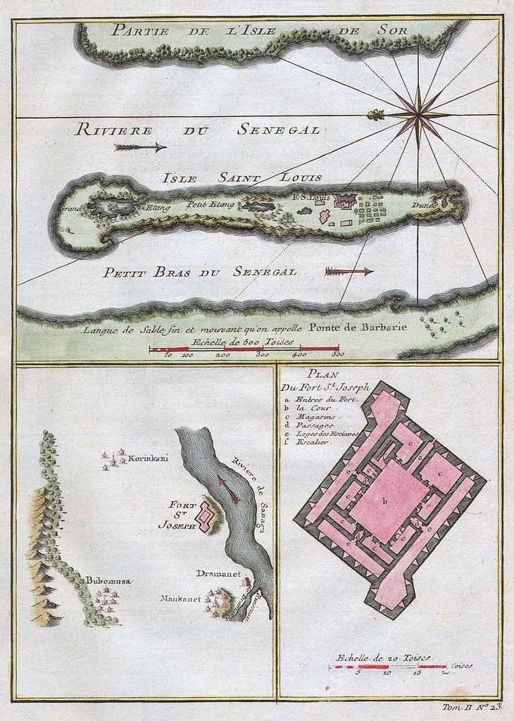
| Jacques-Nicolas Bellin: Riviere du Senegal - Isle Saint Louis - Petit Bras du Senegal - Plan du Fort St. Joseph.
( |
||||||||||||||||||||
|---|---|---|---|---|---|---|---|---|---|---|---|---|---|---|---|---|---|---|---|---|
| Umjetnik/stvaratelj |
|
|||||||||||||||||||
| Naziv |
Riviere du Senegal - Isle Saint Louis - Petit Bras du Senegal - Plan du Fort St. Joseph. |
|||||||||||||||||||
| Opis |
English: This stunning 1747 nautical chart by French mapmaker J. C. Bellin, the Elder depicts the Senegal River and the area surrounding Fort St. Joseph & Fort St. Louis. This region was part of the Senegambia & the Company of the Indies Senegal Concession. It was from this port that the French company shipped hundreds of African slaves to its colonies in Louisiana. Today the Senegal River forms the important border between Senegal and Mauritania. This beautiful map depicts individual buildings, trees, and even tiny villages. There is a detailed plan of Fort St. Joseph.. |
|||||||||||||||||||
| Datum | 1750 | |||||||||||||||||||
| Dimenzije | visina: 6,5 in (16,5 cm); Širina: 9 in (22,8 cm) | |||||||||||||||||||
| Inventarni broj |
Geographicus link: Senegal-bellin-1750 |
|||||||||||||||||||
| Izvor/fotograf |
|
|||||||||||||||||||
| Dopuštenje (Naknadna uporaba ove datoteke) |
|
|||||||||||||||||||
Povijest datoteke
Kliknite na datum/vrijeme kako biste vidjeli datoteku kakva je tada bila.
| Datum/Vrijeme | Minijatura | Dimenzije | Suradnik | Komentar | |
|---|---|---|---|---|---|
| sadašnja | 22:30, 15. ožujka 2011. | | 1.985 × 2.784 (1,13 MB) | BotMultichill | {{subst:User:Multichill/Geographicus |link=http://www.geographicus.com/P/AntiqueMap/Senegal-bellin-1750 |product_name=1750 Bellin Map of the Senegal |map_title=Riviere du Senegal - Isle Saint Louis - Petit Bras du Senegal - Plan du Fort St. Joseph. |des |
Uporaba datoteke
Nijedna stranica ne rabi ovu datoteku.