
Datoteka:Lizars Mexico & Guatimala 1831 UTA.jpg
Veličina ovog prikaza: 708 × 600 piksela. Ostale razlučivosti: 283 × 240 piksela | 567 × 480 piksela | 907 × 768 piksela | 1.209 × 1.024 piksela | 2.418 × 2.048 piksela | 6.185 × 5.238 piksela.
Vidi sliku u punoj veličini (6.185 × 5.238 piksela, veličina datoteke: 11,59 MB, MIME tip: image/jpeg)
| Ova je datoteka sa Zajedničkog poslužitelja i mogu je rabiti drugi projekti. Opis s njezine stranice s opisom datoteke prikazan je ispod. |
Sažetak
| Naslov |
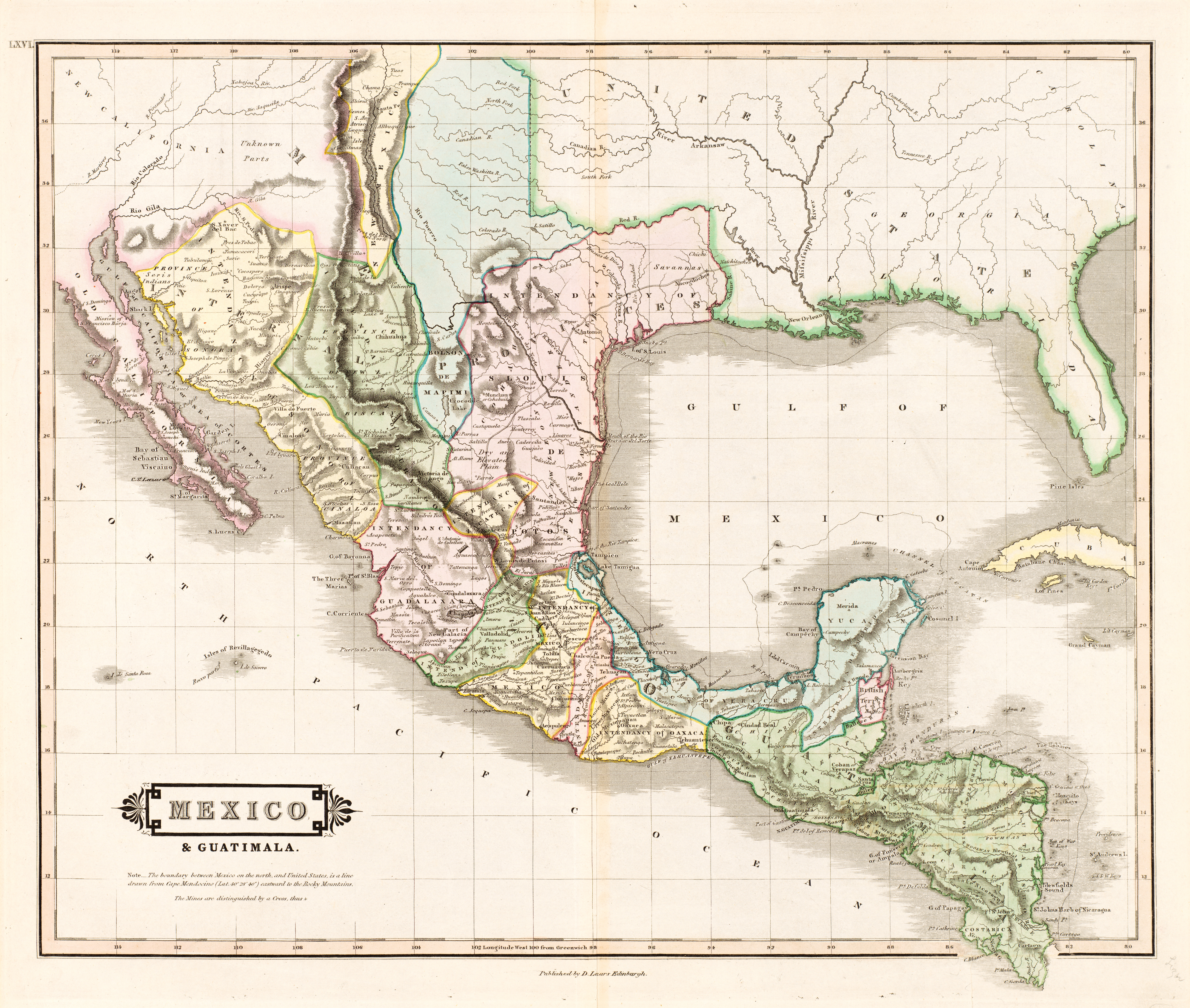
English: Mexico & Guatimala [sic] |
||||||||||||||||||||||||||
| Descripcion |
English: The creator of this map was probably Daniel Lizars II (1793-1875), the son of Edinburgh map engraver and publisher Daniel Lizars I (1754-1812) and younger brother of William Home Lizars (1788-1859). Shortly after producing the map, Daniel II went bankrupt in 1832 and emigrated to Canada in 1833. Lizars' map shows Mexico's administrative districts as Intendencies (Intendencias) and Internal Provinces (Provincias Internas) dating from the Spanish era. His depiction of the area that became Texas is notably jarring to modern viewers because his map further exaggerated some of the cartographic errors of his predecessors and contemporaries: particularly, a southerly "dip" of the middle Red River and the southerly courses of the Trinity, Brazos, and Colorado Rivers (which actually flow southeasterly). Settlements shown include Nacogdoches, "St." Antonio, and "Loredo". Interestingly, Lizars included the "British Territory" that became British Honduras or Belize. British logging settlements existed in the territory by the late eighteenth century and, although the British government had been hesitant to create a colony for fear of provoking the Spanish, settlers there were largely self-governing. |
||||||||||||||||||||||||||
| Datum | oko 1831 | ||||||||||||||||||||||||||
| Izvor | UTA Libraries Cartographic Connections: zemljovid / text | ||||||||||||||||||||||||||
| Stvaratelj |
|
||||||||||||||||||||||||||
| Darovatelj |
English: The University of Texas at Arlington Libraries Special Collections, Gift of Virginia Garrett |
||||||||||||||||||||||||||
| Geotemporal data | |||||||||||||||||||||||||||
| Map location |
Meksiko Gvatemala Teksas |
||||||||||||||||||||||||||
| Georeferencing | If inappropriate please set warp_status = skip to hide. | ||||||||||||||||||||||||||
| Bibliographic data | |||||||||||||||||||||||||||
| Publikacija |
The Edinburgh Geographical and Historical Atlas |
||||||||||||||||||||||||||
| Autor |
John Hamilton |
||||||||||||||||||||||||||
| Mjesto izdavanja |
Edinburgh London Dublin |
||||||||||||||||||||||||||
| Izdavač |
John Hamilton Whittaker, Treacher & Co. W. Curry, Jun. & Co. |
||||||||||||||||||||||||||
| Archival data | |||||||||||||||||||||||||||
| Muzejska zbirka |
|
||||||||||||||||||||||||||
| Dimenzije | visina: 42 cm; Širina: 51,5 cm | ||||||||||||||||||||||||||
| Medij | colored engraving on paper | ||||||||||||||||||||||||||
| artwork-references |
Worms, Laurence; Ashley Baynton-Williams (2011) British Map Engravers, London: Rare Book Society, pp. 406–409 |
||||||||||||||||||||||||||
| Ostale inačice | |||||||||||||||||||||||||||
.jpg)
Licencija

|
This file was provided to Wikimedia Commons by the University of Texas at Arlington Libraries as part of a cooperation project. The University of Texas at Arlington Libraries is part of the University of Texas at Arlington, a public research university located in Arlington, Texas.
|
|
Autor je umro 1875., tako da je ovo djelo u javnom vlasništvu u zemlji podrijetla i u drugim zemljama s rokom trajanja autorskih prava za života autora plus 100 godina ili manje. Ovo je djelo u javnom vlasništvu u SAD-u zato jer je objavljeno (ili registrirano pri Uredu za autorska prava Sjedinjenih Američkih Država) prije 1. siječnja 1929. | |
| Ova datoteka je identificirana kao slobodna od poznatih ograničenja po zakonu o autorskim pravima, uključujući sva povezana i srodna prava. | |
Povijest datoteke
Kliknite na datum/vrijeme kako biste vidjeli datoteku kakva je tada bila.
| Datum/Vrijeme | Minijatura | Dimenzije | Suradnik | Komentar | |
|---|---|---|---|---|---|
| sadašnja | 15:26, 13. srpnja 2019. | | 6.185 × 5.238 (11,59 MB) | Michael Barera | == {{int:filedesc}} == {{Map |title = ''Mexico & Guatimala'' [sic] |description = {{en|The creator of this map was probably Daniel Lizars II (1793-1875), the son of Edinburgh map engraver and publisher Daniel Lizars I (1754-1812) and younger brother of William Home Lizars (1788-1859). Shortly after producing the map, Daniel II went bankrupt in 1832 and emigrated to Canada in 1833. Lizars' map shows Mexico's administrative districts as Intendencies (''Intendencias'') and In... |
Uporaba datoteke
Na ovu sliku vode poveznice sa sljedećih stranica:
Globalna uporaba datoteke
Sljedeći wikiji rabe ovu datoteku:
- Uporaba na en.wikipedia.org
- Uporaba na es.wikipedia.org
- Uporaba na sh.wikipedia.org