
Datoteka:Matakana 2020-04-25 Sentinel 2 SR.jpg

Vidi sliku u punoj veličini (1.920 × 1.310 piksela, veličina datoteke: 1,1 MB, MIME tip: image/jpeg)
| Ova je datoteka sa Zajedničkog poslužitelja i mogu je rabiti drugi projekti. Opis s njezine stranice s opisom datoteke prikazan je ispod. |
Sažetak
| Descripcion |
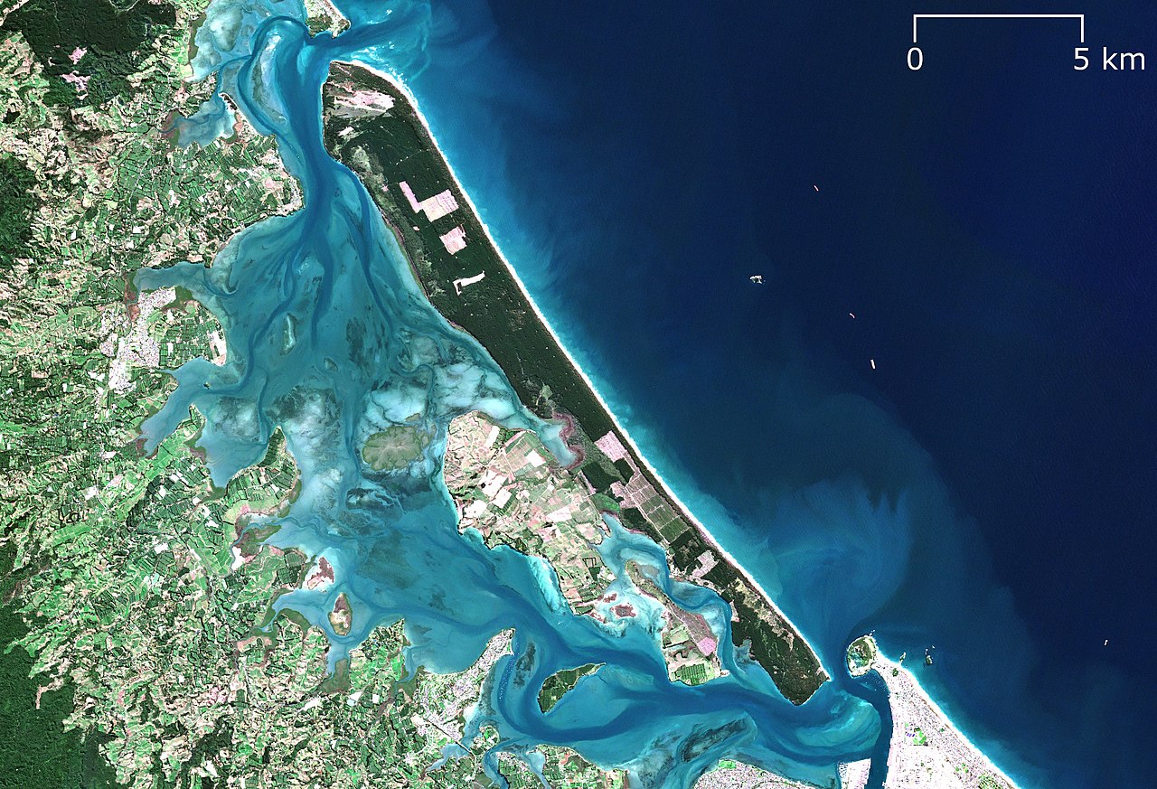
English: Sentinel 2 surface reflectance image of Matakana Island, Bay of Plenty/Te Moana-a-Toi, New Zealand/Aotearoa on 2020-04-25 as an example of a barrier island. |
|||||||||
| PNG Development | ||||||||||
| Datum | ||||||||||
| Izvor | Contains modified Copernicus Sentinel data 2020. European Space Agency. | |||||||||
| Stvaratelj |
European Space Agency, RXerself |
|||||||||
| Geotemporal data | ||||||||||
| Spatial reference system | New Zealand Transverse Mercator 2000 (NZTM2000) | |||||||||
| Heading |
 |
|||||||||
| Bounding box |
|
|||||||||

Licencija
- Slobodno smijete:
- dijeliti – umnožavati, distribuirati i javnosti priopćavati djelo
- remiksirati – prerađivati djelo
- Pod sljedećim uvjetima:
- imenovanje autora – Morate pripisati odgovarajuće autorske zasluge, dati poveznicu na licenciju, te naznačiti jesu li načinjene promjene autorskog djela. Prethodno navedeno možete učiniti na svaki razuman način, ali ne na način koji bi sugerirao da Vi ili Vaše korištenje licencorova djela ima izravno licencorovo odobrenje.
- dijeli pod istim uvjetima – Ako ovo djelo izmijenite, preoblikujete ili stvarate na osnovu tog materijala, svoje doprinose morate distribuirati pod istom ili kompatibilnom licencijom kao što je i licencija originala.

|
This image contains data from a satellite in the Copernicus Programme, such as Sentinel-1, Sentinel-2 or Sentinel-3. Attribution is required when using this image.
Autor: Contains modified Copernicus Sentinel data 2020
The use of Copernicus Sentinel Data is regulated under EU law (Commission Delegated Regulation (EU) No 1159/2013 and Regulation (EU) No 377/2014). Relevant excerpts:
Free access shall be given to GMES dedicated data [...] made available through GMES dissemination platforms [...].
Access to GMES dedicated data [...] shall be given for the purpose of the following use in so far as it is lawful:
GMES dedicated data [...] may be used worldwide without limitations in time.
GMES dedicated data and GMES service information are provided to users without any express or implied warranty, including as regards quality and suitability for any purpose. |
Povijest datoteke
Kliknite na datum/vrijeme kako biste vidjeli datoteku kakva je tada bila.
| Datum/Vrijeme | Minijatura | Dimenzije | Suradnik | Komentar | |
|---|---|---|---|---|---|
| sadašnja | 05:38, 4. rujna 2022. | | 1.920 × 1.310 (1,1 MB) | RXerself | == {{int:filedesc}} == {{Map |description ={{en|1=Sentinel 2 surface reflectance image of Matakana Island, Bay of Plenty/Te Moana-a-Toi, New Zealand/Aotearoa on 2020-04-25 as an example of a {{w|barrier island}}.}} |date =2020-04-25 |source=Contains modified Copernicus Sentinel data 2020. European Space Agency. |author=European Space Agency, {{u|RXerself}} |projection = New Zealand Transverse Mercator 2000 (NZTM2000) |heading = N |latitude =-37.67371/-37.66348/-37.451... |
Uporaba datoteke
Na ovu sliku vode poveznice sa sljedećih stranica:
Globalna uporaba datoteke
Sljedeći wikiji rabe ovu datoteku:
- Uporaba na id.wikipedia.org