
Datoteka:Partition of India.PNG

Viša rezolucija nije dostupna.
Partition_of_India.PNG (450 × 400 piksela, veličina datoteke: 27 KB, MIME tip: image/png)
| Ova je datoteka sa Zajedničkog poslužitelja i mogu je rabiti drugi projekti. Opis s njezine stranice s opisom datoteke prikazan je ispod. |

|
This historical map image could be re-created using vector graphics as an SVG file. This has several advantages; see Commons:Media for cleanup for more information. If an SVG form of this image is available, please upload it and afterwards replace this template with
{{vector version available|new image name}}.
It is recommended to name the SVG file “Partition of India.svg”—then the template Vector version available (or Vva) does not need the new image name parameter. |

|
This map has been uploaded by Electionworld from en.wikipedia.org to enable the |
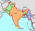
Map showing the Partition of India, by McMullen
| Ja, nositelj autorskog prava za ovo djelo, prepuštam ovo djelo u javno vlasništvo. Ovo prepuštanje vrijedi za cijeli svijet. U nekim državama to nije pravno moguće; ako je tako: Dajem svima prava da koriste ovo djelo za bilo koju svrhu, bez ikakvih uvjeta, osim ako takvi uvjeti nisu propisani zakonom. |
[]
-
 English
 -
 English
 -
 Esperanto
 -
 español
 -
 français
 -
 italiano
 -
 magyar
 -
 Bahasa Melayu
 -
 polski
 -
 нохчийн
 -
 русский
 -
 मराठी
मराठी -
 हिन्दी
 -
 বাংলা
বাংলা -
 বাংলা
বাংলা -
 ਪੰਜਾਬੀ
 -
 ગુજરાતી
 -
 ಕನ್ನಡ
ಕನ್ನಡ -
 עברית
עברית -
 سنڌي
سنڌي -
 اردو
اردو -
 العربية
 -
 فارسی
فارسی


.svg)


Povijest datoteke
Kliknite na datum/vrijeme kako biste vidjeli datoteku kakva je tada bila.
| Datum/Vrijeme | Minijatura | Dimenzije | Suradnik | Komentar | |
|---|---|---|---|---|---|
| sadašnja | 08:58, 20. studenoga 2018. | | 450 × 400 (27 KB) | ARR8 | |
| 00:51, 14. prosinca 2006. |  | 450 × 400 (19 KB) | Electionworld | {{ew|en|McMullen}} Map showing the Partition of India, by McMullen {{PD-self}} |
Uporaba datoteke
Na ovu sliku vode poveznice sa sljedećih stranica:
Globalna uporaba datoteke
Sljedeći wikiji rabe ovu datoteku:
- Uporaba na anp.wikipedia.org
- Uporaba na ar.wikipedia.org
- Uporaba na ast.wikipedia.org
- Uporaba na ca.wikipedia.org
- Uporaba na ckb.wikipedia.org
- Uporaba na el.wikipedia.org
- Uporaba na en.wikipedia.org
- Uporaba na en.wikivoyage.org
- Uporaba na es.wikipedia.org
- Uporaba na et.wikipedia.org
- Uporaba na gu.wikipedia.org
- Uporaba na id.wikipedia.org
- Uporaba na io.wikipedia.org
- Uporaba na ja.wikipedia.org
- Uporaba na ka.wikipedia.org
- Uporaba na nl.wikipedia.org
- Uporaba na ru.wikipedia.org
- Uporaba na sh.wikipedia.org
- Uporaba na sq.wikipedia.org
- Uporaba na sr.wikipedia.org
- Uporaba na ta.wikiquote.org
- Uporaba na te.wikipedia.org
- Uporaba na uk.wikipedia.org
- Uporaba na www.wikidata.org
- Uporaba na zh-yue.wikipedia.org
- Uporaba na zh.wikipedia.org