
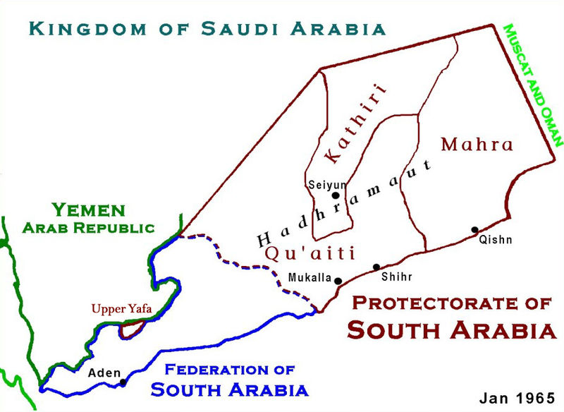
Datoteka:ProtectorateOfSouthArabiaMap.jpg

Veličina ovog prikaza: 800 × 584 piksela. Ostale razlučivosti: 320 × 234 piksela | 640 × 467 piksela | 912 × 666 piksela.
Vidi sliku u punoj veličini (912 × 666 piksela, veličina datoteke: 273 KB, MIME tip: image/jpeg)
| Ova je datoteka sa Zajedničkog poslužitelja i mogu je rabiti drugi projekti. Opis s njezine stranice s opisom datoteke prikazan je ispod. |

|
This historical map image could be re-created using vector graphics as an SVG file. This has several advantages; see Commons:Media for cleanup for more information. If an SVG form of this image is available, please upload it and afterwards replace this template with
{{vector version available|new image name}}.
It is recommended to name the SVG file “ProtectorateOfSouthArabiaMap.svg”—then the template Vector version available (or Vva) does not need the new image name parameter. |


|
This map has been uploaded by Electionworld from en.wikipedia.org to enable the |
Sažetak
Based on Work of US Government agency. Another version in russian is available.
Licencija
This work is in the public domain in the United States because it is a work prepared by an officer or employee of the United States Government as part of that person’s official duties under the terms of Title 17, Chapter 1, Section 105 of the US Code.
Note: This only applies to original works of the Federal Government and not to the work of any individual U.S. state, territory, commonwealth, county, municipality, or any other subdivision. This template also does not apply to postage stamp designs published by the United States Postal Service since 1978. (See § 313.6(C)(1) of Compendium of U.S. Copyright Office Practices). It also does not apply to certain US coins; see The US Mint Terms of Use.
|
 | |
| Ova datoteka je identificirana kao slobodna od poznatih ograničenja po zakonu o autorskim pravima, uključujući sva povezana i srodna prava. | ||
Povijest datoteke
Kliknite na datum/vrijeme kako biste vidjeli datoteku kakva je tada bila.
| Datum/Vrijeme | Minijatura | Dimenzije | Suradnik | Komentar | |
|---|---|---|---|---|---|
| sadašnja | 04:12, 18. siječnja 2010. | | 912 × 666 (273 KB) | Anonimosanhueza | borders removed |
| 03:14, 28. studenoga 2008. |  | 928 × 682 (284 KB) | Nickpo | {{svg|map}} {{ew|en|AjaxSmack}} == Summary == Based on Work of US Government agency == Licensing == {{PD-USGov}} Category:Maps of Yemen Category:Qu'aiti State of Shihr and Mukalla Category:Federation of South Arabia [[Category:Kathiri State | |
| 00:56, 18. prosinca 2006. |  | 928 × 682 (118 KB) | Electionworld | {{ew|en|AjaxSmack}} == Summary == Based on Work of US Government agency == Licensing == {{PD-USGov}} |
Uporaba datoteke
Na ovu sliku vode poveznice sa sljedećih stranica:
Globalna uporaba datoteke
Sljedeći wikiji rabe ovu datoteku:
- Uporaba na ar.wikipedia.org
- Uporaba na be.wikipedia.org
- Uporaba na bn.wikipedia.org
- Uporaba na ca.wikipedia.org
- Uporaba na cs.wikipedia.org
- Uporaba na de.wikipedia.org
- Uporaba na en.wikipedia.org
- Uporaba na es.wikipedia.org
- Uporaba na fr.wikipedia.org
- Uporaba na fr.wiktionary.org
- Uporaba na id.wikipedia.org
- Uporaba na it.wikipedia.org
- Uporaba na ja.wikipedia.org
- Uporaba na lt.wikipedia.org
- Uporaba na mk.wikipedia.org
- Uporaba na no.wikipedia.org
- Uporaba na pl.wikipedia.org
- Uporaba na pnb.wikipedia.org
- Uporaba na pt.wikipedia.org
- Uporaba na ru.wikipedia.org
Pogledajte globalnu uporabu ove datoteke.