
Datoteka:RabaulStrategicArea.jpg

Veličina ovog prikaza: 800 × 463 piksela. Ostale razlučivosti: 320 × 185 piksela | 640 × 371 piksela | 1.024 × 593 piksela | 1.280 × 741 piksela | 2.500 × 1.448 piksela.
Vidi sliku u punoj veličini (2.500 × 1.448 piksela, veličina datoteke: 535 KB, MIME tip: image/jpeg)
| Ova je datoteka sa Zajedničkog poslužitelja i mogu je rabiti drugi projekti. Opis s njezine stranice s opisom datoteke prikazan je ispod. |
Sažetak
| Opis |
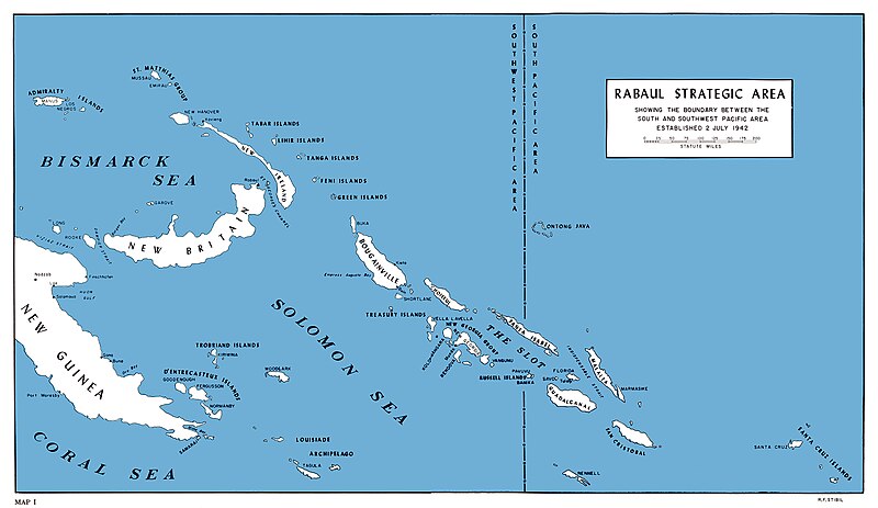
English: U.S. Marine map of SouthWest Pacific area, 1942 |
| Datum | |
| Izvor | [1] [2] Melson, Charles D. (1993). UP THE SLOT: Marines in the Central Solomons. WORLD WAR II COMMEMORATIVE SERIES 36. History and Museums Division, Headquarters, U.S. Marine Corps. Retrieved on Sept 26. |
| Autor | Charles D. Melson; Cartographic and visual information: George C. MacGillivray and W. Stephen Hill |
![[1]](http://www.ibiblio.org/hyperwar/USMC/USMC-C-CSol/maps/USMC-C-CSol-1.jpg)
Licencija
This work is in the public domain in the United States because it is a work prepared by an officer or employee of the United States Government as part of that person’s official duties under the terms of Title 17, Chapter 1, Section 105 of the US Code.
Note: This only applies to original works of the Federal Government and not to the work of any individual U.S. state, territory, commonwealth, county, municipality, or any other subdivision. This template also does not apply to postage stamp designs published by the United States Postal Service since 1978. (See § 313.6(C)(1) of Compendium of U.S. Copyright Office Practices). It also does not apply to certain US coins; see The US Mint Terms of Use.
|
 | |
| Ova datoteka je identificirana kao slobodna od poznatih ograničenja po zakonu o autorskim pravima, uključujući sva povezana i srodna prava. | ||
Povijest datoteke
Kliknite na datum/vrijeme kako biste vidjeli datoteku kakva je tada bila.
| Datum/Vrijeme | Minijatura | Dimenzije | Suradnik | Komentar | |
|---|---|---|---|---|---|
| sadašnja | 17:09, 5. svibnja 2020. | | 2.500 × 1.448 (535 KB) | Hohum | Clearer version |
| 20:28, 14. svibnja 2018. |  | 1.200 × 669 (308 KB) | Hohum | Cleanup | |
| 18:16, 27. lipnja 2006. |  | 1.200 × 669 (177 KB) | Cla68 | U.S. Marine map of SouthWest Pacific area, 1942. http://www.ibiblio.org/hyperwar/USMC/USMC-C-CSol/index.html. |
Uporaba datoteke
Na ovu sliku vode poveznice sa sljedećih stranica:
Globalna uporaba datoteke
Sljedeći wikiji rabe ovu datoteku:
- Uporaba na ar.wikipedia.org
- Uporaba na ast.wikipedia.org
- Uporaba na da.wikipedia.org
- Uporaba na en.wikipedia.org
- Uporaba na es.wikipedia.org
- Uporaba na fr.wikipedia.org
- Uporaba na he.wikipedia.org
- Uporaba na id.wikipedia.org
- Uporaba na it.wikipedia.org
- Uporaba na no.wikipedia.org
- Uporaba na pl.wikipedia.org
- Uporaba na ru.wikipedia.org
- Uporaba na sh.wikipedia.org
- Uporaba na sr.wikipedia.org
- Uporaba na uk.wikipedia.org
- Uporaba na zh.wikipedia.org