
Datoteka:Allied lines of communication in Southeast Asia, 1942-43.jpg
Veličina ovog prikaza: 779 × 600 piksela. Ostale razlučivosti: 312 × 240 piksela | 624 × 480 piksela | 998 × 768 piksela | 1.260 × 970 piksela.
Vidi sliku u punoj veličini (1.260 × 970 piksela, veličina datoteke: 450 KB, MIME tip: image/jpeg)
| Ova je datoteka sa Zajedničkog poslužitelja i mogu je rabiti drugi projekti. Opis s njezine stranice s opisom datoteke prikazan je ispod. |

|
This historical map image could be re-created using vector graphics as an SVG file. This has several advantages; see Commons:Media for cleanup for more information. If an SVG form of this image is available, please upload it and afterwards replace this template with
{{vector version available|new image name}}.
It is recommended to name the SVG file “Allied lines of communication in Southeast Asia, 1942-43.svg”—then the template Vector version available (or Vva) does not need the new image name parameter. |


Sažetak
| Opis |
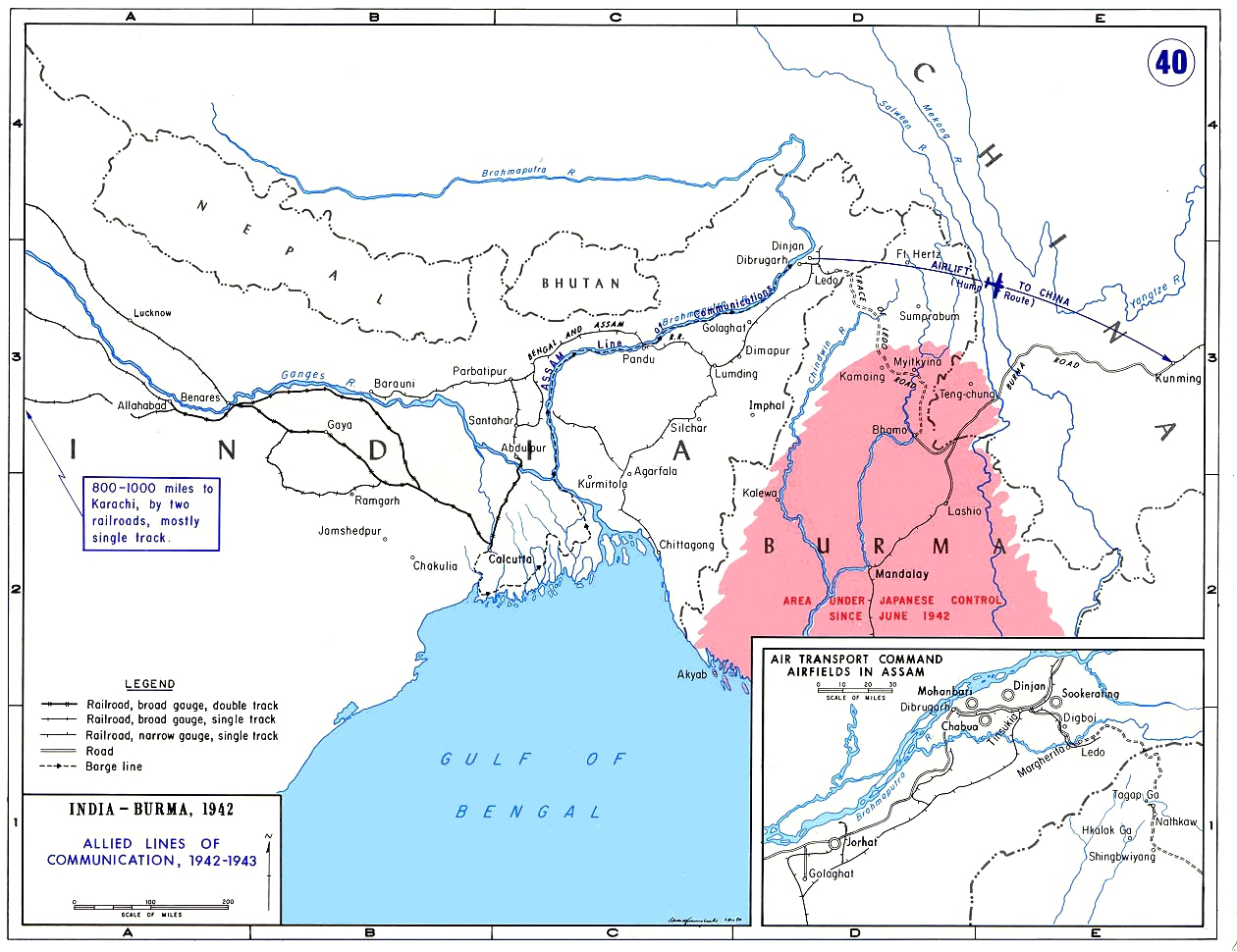
English: Allied lines of communication in India, Burma, and China in 1942–43. |
| Datum | nepoznat datum |
| Izvor | [1] |
| Autor | The Department of History, United States Military Academy |
| Dopuštenje (Naknadna uporaba ove datoteke) |
In the public domain as an original work of the United States federal government and/or military [2] |
Licencija
This work is in the public domain in the United States because it is a work prepared by an officer or employee of the United States Government as part of that person’s official duties under the terms of Title 17, Chapter 1, Section 105 of the US Code.
Note: This only applies to original works of the Federal Government and not to the work of any individual U.S. state, territory, commonwealth, county, municipality, or any other subdivision. This template also does not apply to postage stamp designs published by the United States Postal Service since 1978. (See § 313.6(C)(1) of Compendium of U.S. Copyright Office Practices). It also does not apply to certain US coins; see The US Mint Terms of Use.
|
 | |
| Ova datoteka je identificirana kao slobodna od poznatih ograničenja po zakonu o autorskim pravima, uključujući sva povezana i srodna prava. | ||
Povijest datoteke
Kliknite na datum/vrijeme kako biste vidjeli datoteku kakva je tada bila.
| Datum/Vrijeme | Minijatura | Dimenzije | Suradnik | Komentar | |
|---|---|---|---|---|---|
| sadašnja | 19:02, 29. prosinca 2013. | | 1.260 × 970 (450 KB) | Hohum | Cleanup |
| 04:16, 30. kolovoza 2006. |  | 1.260 × 970 (176 KB) | Kirill Lokshin | {{Information |Description= Allied lines of communication in India, Burma, and China in 1942–43. |Source= [http://www.dean.usma.edu/history/web03/atlases/ww2%20pacific/ww2%20pacific%20%20pages/ww2%20pacific%20map%2040.htm] |Date= ? |Author= [http://www |
Uporaba datoteke
Na ovu sliku vode poveznice sa sljedećih stranica:
Globalna uporaba datoteke
Sljedeći wikiji rabe ovu datoteku:
- Uporaba na ast.wikipedia.org
- Uporaba na as.wikipedia.org
- Uporaba na da.wikipedia.org
- Uporaba na de.wikipedia.org
- Uporaba na en.wikipedia.org
- Uporaba na es.wikipedia.org
- Uporaba na fa.wikipedia.org
- Uporaba na fr.wikipedia.org
- Uporaba na gu.wikipedia.org
- Uporaba na he.wikipedia.org
- Uporaba na hi.wikipedia.org
- Uporaba na id.wikipedia.org
- Uporaba na it.wikipedia.org
- Uporaba na ja.wikipedia.org
- Uporaba na lv.wikipedia.org
- Uporaba na my.wikipedia.org
- Uporaba na nl.wikipedia.org
- Uporaba na no.wikipedia.org
- Uporaba na pt.wikipedia.org
- Uporaba na ru.wikipedia.org
- Uporaba na sh.wikipedia.org
- Uporaba na www.wikidata.org
- Uporaba na zh.wikipedia.org