
Datoteka:ShepherdByzempire1265.jpg
Vidi sliku u punoj veličini (1.144 × 900 piksela, veličina datoteke: 281 KB, MIME tip: image/jpeg)
| Ova je datoteka sa Zajedničkog poslužitelja i mogu je rabiti drugi projekti. Opis s njezine stranice s opisom datoteke prikazan je ispod. |
Sažetak
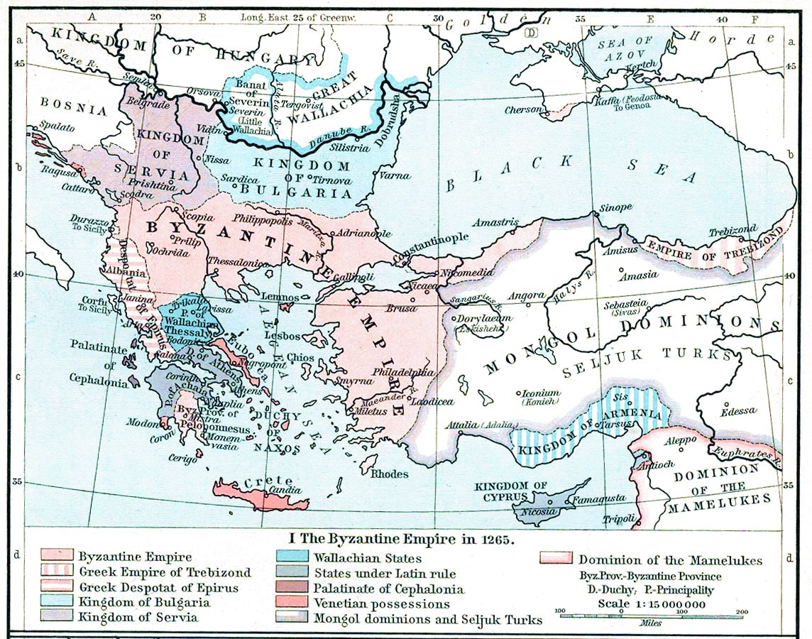
| Opis | Map, The Byzantine Empire, 1265. | ||||||||||||||||||||||
| Datum | |||||||||||||||||||||||
| Izvor | The Historical Atlas, William R. Shepherd, 1911. | ||||||||||||||||||||||
| Autor |
|
||||||||||||||||||||||
| Ostale inačice |
Radovi izvedeni od ove datoteke: |
||||||||||||||||||||||

|
This old map image could be re-created using vector graphics as an SVG file. This has several advantages; see Commons:Media for cleanup for more information. If an SVG form of this image is available, please upload it and afterwards replace this template with
{{vector version available|new image name}}.
It is recommended to name the SVG file “ShepherdByzempire1265.svg”—then the template Vector version available (or Vva) does not need the new image name parameter. |


Licencija
|
Ovo je djelo u javnom vlasništvu u zemlji podrijetla i u drugim zemljama s rokom trajanja autorskih prava za života autora plus 70 godina ili manje.
| |
| Ova datoteka je identificirana kao slobodna od poznatih ograničenja po zakonu o autorskim pravima, uključujući sva povezana i srodna prava. | |
This media file is in the public domain in the United States. This applies to U.S. works where the copyright has expired, often because its first publication occurred prior to January 1, 1929, and if not then due to lack of notice or renewal. See this page for further explanation.
|
 | |
 |
This image might not be in the public domain outside of the United States; this especially applies in the countries and areas that do not apply the rule of the shorter term for US works, such as Canada, Mainland China (not Hong Kong or Macao), Germany, Mexico, and Switzerland. The creator and year of publication are essential information and must be provided. See Wikipedia:Public domain and Wikipedia:Copyrights for more details.
|
Povijest datoteke
Kliknite na datum/vrijeme kako biste vidjeli datoteku kakva je tada bila.
| Datum/Vrijeme | Minijatura | Dimenzije | Suradnik | Komentar | |
|---|---|---|---|---|---|
| sadašnja | 17:28, 16. studenoga 2022. | | 1.144 × 900 (281 KB) | Gyalu22 | Reverted to version as of 16:26, 12 July 2009 (UTC) |
| 16:49, 20. svibnja 2016. |  | 1.144 × 900 (858 KB) | Julieta39 | Cosmetic (see discussion file) | |
| 18:26, 12. srpnja 2009. |  | 1.144 × 900 (281 KB) | Alex:D | whitened | |
| 18:17, 12. srpnja 2009. |  | 1.144 × 900 (281 KB) | Alex:D | whitened | |
| 18:12, 12. srpnja 2009. |  | 1.144 × 900 (281 KB) | Alex:D | whitened | |
| 15:40, 21. prosinca 2004. |  | 1.144 × 900 (272 KB) | Mschlindwein | Map, The Byzantine Empire, 1265. The Historical Atlas, William R. Shepherd, 1911. |
Uporaba datoteke
Na ovu sliku vode poveznice sa sljedećih stranica:
Globalna uporaba datoteke
Sljedeći wikiji rabe ovu datoteku:
- Uporaba na an.wikipedia.org
- Uporaba na ar.wikipedia.org
- Uporaba na azb.wikipedia.org
- Uporaba na az.wikipedia.org
- Uporaba na be-tarask.wikipedia.org
- Uporaba na be.wikipedia.org
- Uporaba na bg.wikipedia.org
- Uporaba na ca.wikipedia.org
- Uporaba na cs.wikipedia.org
- Uporaba na de.wikipedia.org
- Uporaba na el.wikipedia.org
- Uporaba na en.wikipedia.org
Pogledajte globalnu uporabu ove datoteke.