
Datoteka:Syrian, Iraqi, and Lebanese insurgencies.png

Vidi sliku u punoj veličini (4.509 × 3.449 piksela, veličina datoteke: 1,74 MB, MIME tip: image/png)
| Ova je datoteka sa Zajedničkog poslužitelja i mogu je rabiti drugi projekti. Opis s njezine stranice s opisom datoteke prikazan je ispod. |
Sažetak

|
This file may be updated to reflect new information. If you wish to use a specific version of the file without new updates being mirrored, please upload the required version as a separate file. |
| Opis |
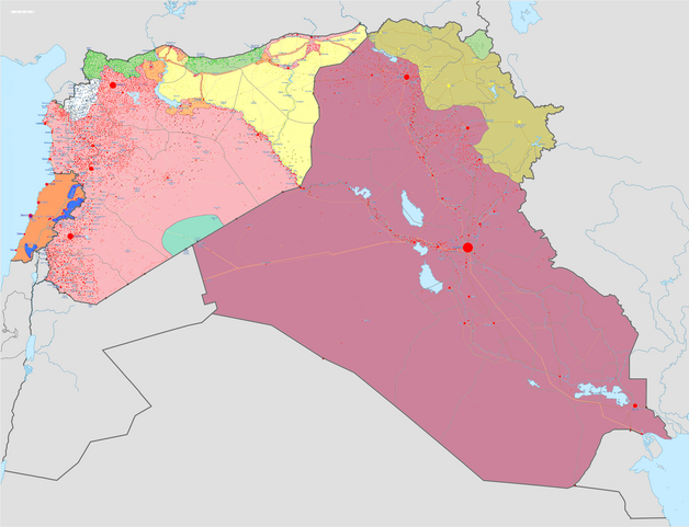
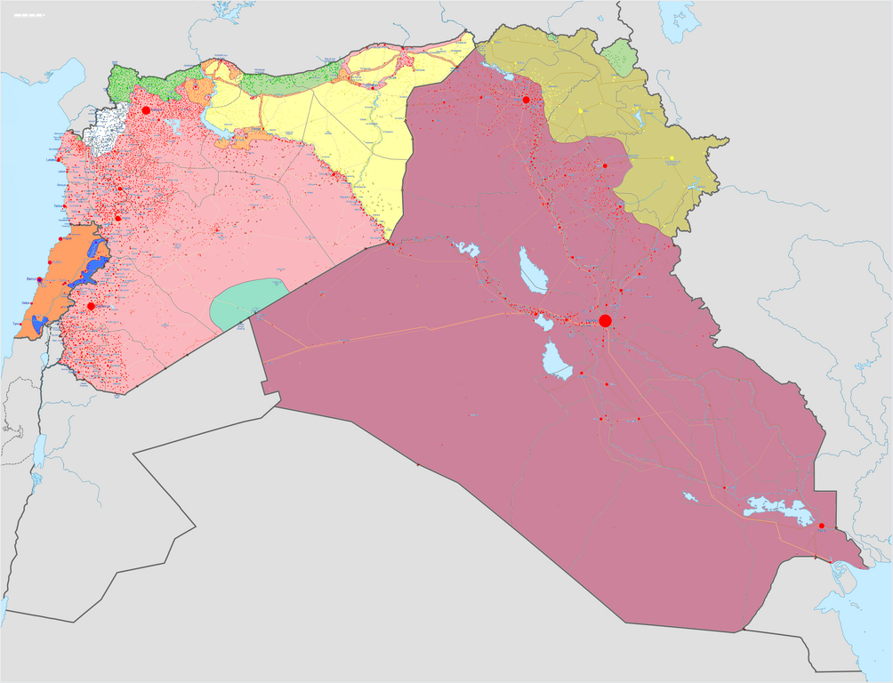
Map of the Syrian Civil War, the Iraq Civil War (2014–present), and the Lebanese insurgency. For previous revisions of the battle map (not including Lebanon) before June 2015, see File:Syria and Iraq 2014-onward War map.png. After updating this map, please also update the date(s) at w:Module:Iraq Syria map date, used to denote the date in articles. Areas under joint SDF-SAA control
In the respective colours: |
||||
| Datum | |||||
| Izvor |
Vlastito djelo postavljača w:en:Template:Syrian, Iraqi, and Lebanese insurgencies detailed map |
||||
| Autor | BlueHypercane761 | ||||
| Ostale inačice |
|


.png)


.svg)


.svg)

.svg)


_Territory_Change_2014-2016.gif)

_(within_Northern_Syria).svg)


.png)
.svg)


_map.png)
.svg)


.svg)


|
This historical map image could be re-created using vector graphics as an SVG file. This has several advantages; see Commons:Media for cleanup for more information. If an SVG form of this image is available, please upload it and afterwards replace this template with
{{vector version available|new image name}}.
It is recommended to name the SVG file “Syrian, Iraqi, and Lebanese insurgencies.svg”—then the template Vector version available (or Vva) does not need the new image name parameter. |

|
This image has a useful history, which can be viewed as an animation. |
Licencija
- Slobodno smijete:
- dijeliti – umnožavati, distribuirati i javnosti priopćavati djelo
- remiksirati – prerađivati djelo
- Pod sljedećim uvjetima:
- imenovanje autora – Morate pripisati odgovarajuće autorske zasluge, dati poveznicu na licenciju, te naznačiti jesu li načinjene promjene autorskog djela. Prethodno navedeno možete učiniti na svaki razuman način, ali ne na način koji bi sugerirao da Vi ili Vaše korištenje licencorova djela ima izravno licencorovo odobrenje.
- dijeli pod istim uvjetima – Ako ovo djelo izmijenite, preoblikujete ili stvarate na osnovu tog materijala, svoje doprinose morate distribuirati pod istom ili kompatibilnom licencijom kao što je i licencija originala.
Povijest datoteke
Kliknite na datum/vrijeme kako biste vidjeli datoteku kakva je tada bila.
| Datum/Vrijeme | Minijatura | Dimenzije | Suradnik | Komentar | |
|---|---|---|---|---|---|
| sadašnja | 13:43, 6. rujna 2020. | | 4.509 × 3.449 (1,74 MB) | LyriaSiders | Reports that the SAA have taken over the Doubayat oil and gas field and surrounding area from ISIL elements. Now there is apparently no more hard control by ISIL in the central desert. |
| 17:10, 24. svibnja 2020. |  | 4.509 × 3.449 (2,21 MB) | Wiz9999 | Updating Revolutionary Commando Army & US presence colour to teal. | |
| 13:27, 7. ožujka 2020. |  | 4.509 × 3.449 (1,74 MB) | Nate Hooper | Update after the Turkish response. Also, see the discussion page for a further update I have planned. | |
| 05:23, 19. veljače 2020. |  | 4.509 × 3.449 (1,75 MB) | Nate Hooper | Update after the Idlib offensive. | |
| 01:45, 8. veljače 2020. |  | 4.509 × 3.449 (1,75 MB) | The Dolly Parton Challenge - Still more country than Alan Jackson | Further SAA advances towards Idlib. | |
| 01:26, 8. veljače 2020. |  | 4.509 × 3.449 (2,51 MB) | The Dolly Parton Challenge - Still more country than Alan Jackson | Reverted to version as of 00:25, 6 February 2020 (UTC) Never mind | |
| 02:32, 6. veljače 2020. |  | 4.509 × 3.449 (2,51 MB) | TheHatingNerdino666 | Fixed the Manbij area. | |
| 02:25, 6. veljače 2020. |  | 4.509 × 3.449 (2,51 MB) | TheHatingNerdino666 | Big update as the Syrian Army continues the push towards Idlib. | |
| 19:05, 7. siječnja 2020. |  | 4.509 × 3.449 (2,27 MB) | Nate Hooper | Wew, it's been a while (I was a way for a bit because I was banned, but I appealed and was successful). Anyway, the SAA have made advances in Idlib. | |
| 19:05, 27. listopada 2019. |  | 4.509 × 3.449 (2,51 MB) | Mlpwtfisthat Backup 7.0 | Remove the date. |
Uporaba datoteke
Nijedna stranica ne rabi ovu datoteku.
Globalna uporaba datoteke
Sljedeći wikiji rabe ovu datoteku:
- Uporaba na ar.wikipedia.org
- Uporaba na arz.wikipedia.org
- Uporaba na de.wikipedia.org
- Uporaba na en.wikipedia.org
- Template talk:Lebanese insurgency detailed map
- Module talk:Syrian, Iraqi, and Lebanese insurgencies detailed map
- Module talk:Syrian and Iraqi insurgency detailed map/Archive 1
- Module talk:Iraqi insurgency detailed map/Archive 4
- Talk:Control of cities during the Syrian civil war/Archive 49
- User:AH bharara/sandbox/Islamic State of Iraq and the Levant affiliated Groups
- Talk:Islamic State/Archive 38
- Wikipedia:Graphics Lab/Map workshop/Archive/2016
- Talk:Islamic State/Archive 40
- Talk:Battle of Mosul (2016–2017)/Archive 1
- Talk:Islamic State/Archive 41
- User:KaldeFakta68/sandbox
- User:Edisonabcd/sandbox
- Uporaba na fa.wikipedia.org
- Uporaba na fr.wikipedia.org
- Uporaba na id.wikipedia.org
- Uporaba na ku.wikipedia.org
- Uporaba na mi.wikipedia.org
- Uporaba na pt.wikinews.org
- Uporaba na tr.wikipedia.org
- Uporaba na www.wikidata.org
- Uporaba na zh.wikipedia.org