
Datoteka:Asia 800ad.jpg
Veličina ovog prikaza: 800 × 463 piksela. Ostale razlučivosti: 320 × 185 piksela | 640 × 370 piksela | 1.024 × 593 piksela | 1.280 × 741 piksela | 2.099 × 1.215 piksela.
Vidi sliku u punoj veličini (2.099 × 1.215 piksela, veličina datoteke: 809 KB, MIME tip: image/jpeg)
| Ova je datoteka sa Zajedničkog poslužitelja i mogu je rabiti drugi projekti. Opis s njezine stranice s opisom datoteke prikazan je ispod. |

|
This historical map image could be re-created using vector graphics as an SVG file. This has several advantages; see Commons:Media for cleanup for more information. If an SVG form of this image is available, please upload it and afterwards replace this template with
{{vector version available|new image name}}.
It is recommended to name the SVG file “Asia 800ad.svg”—then the template Vector version available (or Vva) does not need the new image name parameter. |


Sažetak
| Opis |
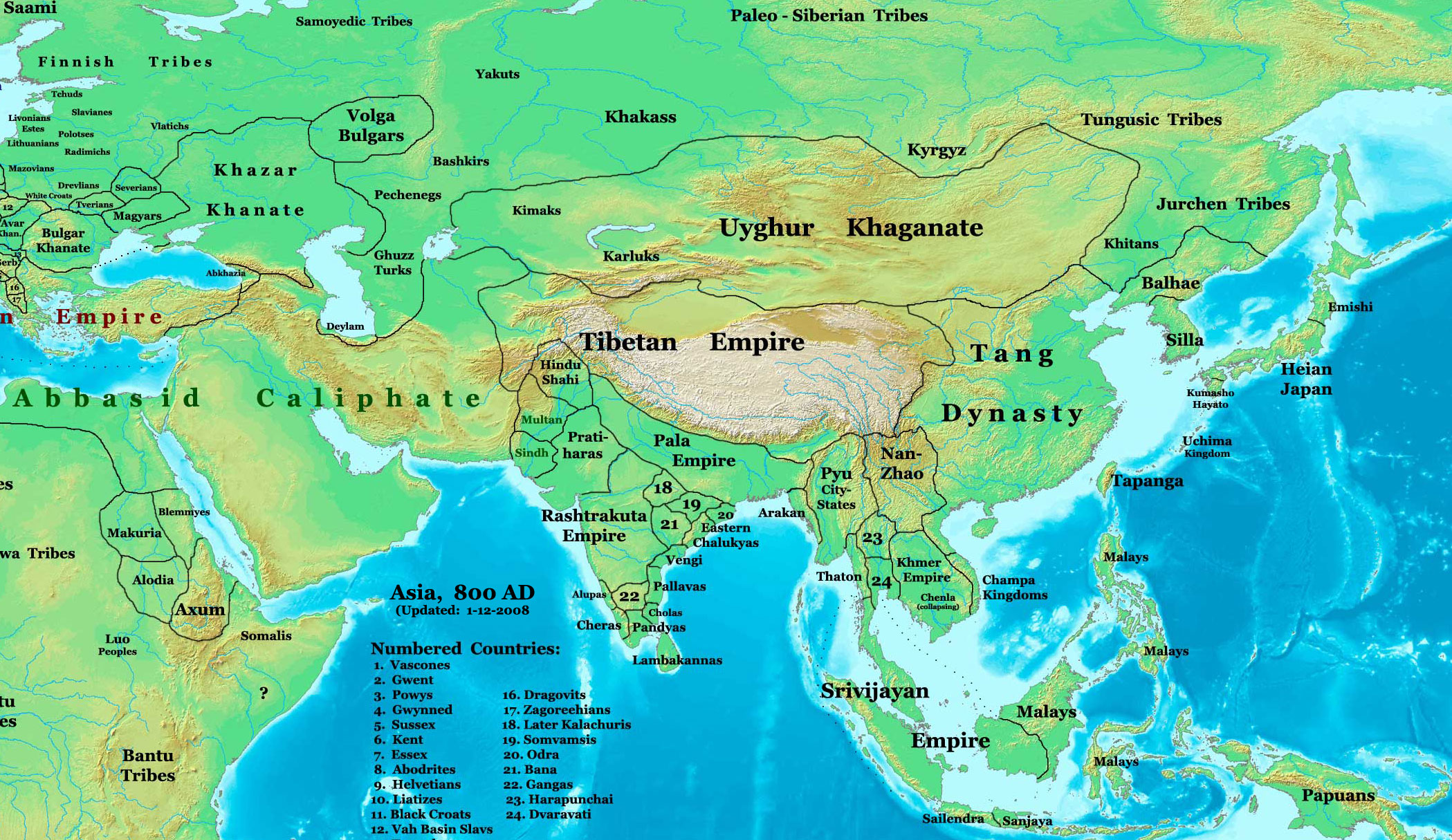
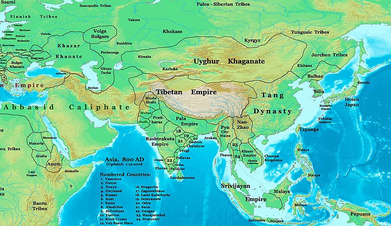
English: This image is a zoomed-in version of Image:East-Hem_800ad.jpg (Eastern Hemisphere in 800 AD).
Author: Thomas A. Lessman. Source URL: http://www.ThomasLessman.com/History/images/East-Hem_800ad.jpg. Image was created by me (Thomas Lessman) based on map of Eastern Hemisphere in 800 AD. Image is free for public and/or educational use. I would appreciate a mention if this image is used elsewhere. If anyone is interested in helping further this work, please contact Thomas Lessman at talessman@yis.us. Other Historical Maps by Thomas Lessman
|
| Datum | 22. listopada 2007. (izvorni datum postavljanja); 29. siječnja 2008. (last version) |
| Izvor | Prebačeno s en.wikipedia na Zajednički poslužitelj Prebacio suradnik Vinhtantran rabeći CommonsHelper. |
| Autor | Talessman na Wikipediji na engleskom jeziku |
| Ostale inačice |
 |


Licencija
Talessman na Wikipediji na engleskom jeziku, nositelj autorskog prava za ovo djelo, ovime ga objavljuje pod sljedećim licencijama:

|
Dozvoljava se umnožavanje, dijeljenje i/ili mijenjanje ovog dokumenta pod uvjetima GNU-ove licence za slobodnu dokumentaciju, inačica 1.2 ili kasnija ako ju je objavio Free Software Foundation; bez nepromjenjivih ili obveznih dijelova i bez teksta na naslovnoj i/ili posljednjoj stranici. Kopija licencije je uključena u odjeljak naslovljen GNU-ove licence za slobodnu dokumentaciju. |
Ova datoteka je licencirana pod licencijom - Creative Commons Imenovanje 3.0 nelokalizirana.
Autor: Talessman na Wikipediji na engleskom jeziku
- Slobodno smijete:
- dijeliti – umnožavati, distribuirati i javnosti priopćavati djelo
- remiksirati – prerađivati djelo
- Pod sljedećim uvjetima:
- imenovanje autora – Morate pripisati odgovarajuće autorske zasluge, dati poveznicu na licenciju, te naznačiti jesu li načinjene promjene autorskog djela. Prethodno navedeno možete učiniti na svaki razuman način, ali ne na način koji bi sugerirao da Vi ili Vaše korištenje licencorova djela ima izravno licencorovo odobrenje.
Možete odabrati licenciju prema vašem izboru.
Izvorna evidencija postavljanja
Izvorna stranica s opisom bila je ovdje. Niže navedena suradnička imena odnose se na en.wikipedia.
- 2008-01-29 22:50 Talessman 2099×1215×8 (828763 bytes) corrected borders of Tibet and others
- 2007-12-10 23:50 Talessman 2106×1450×8 (911289 bytes) (Correct image uploaded this time; earlier upload was the old version...)
- 2007-12-10 23:48 Talessman 1950×1193×8 (695931 bytes) Uploaded most recently corrected version (as of 12-09-2007)
- 2007-10-31 20:39 Talessman 1950×1193×8 (695931 bytes) Corrected borders of Korea, added info on Far eastern islands
- 2007-10-22 19:15 Talessman 1673×1062×8 (553343 bytes) Author: Thomas A. Lessman. Source URL: http://www.ThomasLessman.com/History/images/East-Hem_800ad.jpg. Image was created by me (Thomas Lessman) based on map of Eastern Hemisphere in 800AD. Image is free for public and/or educational use. I would appreciat
Povijest datoteke
Kliknite na datum/vrijeme kako biste vidjeli datoteku kakva je tada bila.
| Datum/Vrijeme | Minijatura | Dimenzije | Suradnik | Komentar | |
|---|---|---|---|---|---|
| sadašnja | 06:46, 23. lipnja 2008. | | 2.099 × 1.215 (809 KB) | File Upload Bot (Magnus Manske) | {{BotMoveToCommons|en.wikipedia}} {{Information |Description={{en|This image is a zoomed-in version of [http://en.wikipedia.org/wiki/Image:East-Hem_800ad.jpg Eastern Hemisphere in 800 AD]. [[:en:Image:East-Hem_800ad.jpg|thumb|300px|left|Eastern Hemispher |
Uporaba datoteke
Nijedna stranica ne rabi ovu datoteku.
Globalna uporaba datoteke
Sljedeći wikiji rabe ovu datoteku:
- Uporaba na azb.wikipedia.org
- Uporaba na ba.wikipedia.org
- Uporaba na bn.wikipedia.org
- Uporaba na en.wikipedia.org
- Bangladesh
- West Bengal
- History of Bangladesh
- Jaisalmer
- Portal:Bangladesh
- Gauḍa (city)
- History of Bihar
- Śāntarakṣita
- Pataliputra
- History of Rajasthan
- Horses in East Asian warfare
- Jaisalmer State
- User:Joelton Ivson/Gather lists/24270 – India
- User:Gauravkumar4291/Notes/GS/Cul/Pala Empire
- Horses in ancient and Imperial China
- Uporaba na fa.wikipedia.org
- Uporaba na fr.wikipedia.org
- Uporaba na hi.wikipedia.org
- Uporaba na incubator.wikimedia.org
- Uporaba na it.wikipedia.org
- Uporaba na ka.wikipedia.org
- Uporaba na kn.wikipedia.org
- Uporaba na ko.wikipedia.org
- Uporaba na mai.wikipedia.org
- Uporaba na my.wikipedia.org
- Uporaba na ne.wikipedia.org
- Uporaba na pt.wikipedia.org
- Uporaba na ru.wikipedia.org
- Uporaba na sl.wikipedia.org
- Uporaba na ta.wikipedia.org
- Uporaba na te.wikipedia.org
- Uporaba na tt.wikipedia.org
- Uporaba na uk.wikipedia.org
- Uporaba na vi.wikipedia.org